IMAGES TAKEN NEAR TO
Station Road North, WALLSEND, NE28 8AA
Introduction
This page details the photographs taken nearby to Station Road North, NE28 8AA by members of the Geograph project.
The Geograph project started in 2005 with the aim of publishing, organising and preserving representative images for every square kilometre of Great Britain, Ireland and the Isle of Man.

There are currently over 7.5m images from over14,400 individuals and you can help contribute to the project by visiting https://www.geograph.org.uk
Image Map (Loading...)


Getting Data...Please wait
Leaflet Map data © OpenStreetMap
Images are licensed for reuse under creativecommons.org/licenses/by-sa/2.0
Notes
- Clicking on the map will re-center to the selected point.
- The higher the marker number, the further away the image location is from the centre of the postcode.
Image Listing (18 Images Found)
Images are licensed for reuse under creativecommons.org/licenses/by-sa/2.0
Image
Details
Distance
3
Wiltshire Gardens 2007 in the distance
Image: © Mac McCarron
Taken: 21 Oct 2007
0.10 miles
4
Wiltshire Gardens "Maisonettes" 2007
The maisonettes were demolished and the land sold for private housing.
Image: © Mac McCarron
Taken: 20 Oct 2007
0.11 miles
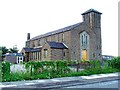
7
The Church of St John The Evangelist, Station Road, Wallsend
Image: © Bill Henderson
Taken: 10 Jun 2012
0.19 miles
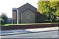
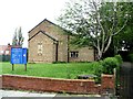
8
St. Bernadette Roman Catholic Church
Situated in the northern part of Wallsend
Image: © Christine Westerback
Taken: 14 Aug 2005
0.21 miles
9
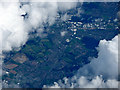
Wallsend from the air
Looking along the A1058 Coast Road from an Edinburgh bound flight from Prague.
Image: © Thomas Nugent
Taken: 18 Aug 2017
0.21 miles
10
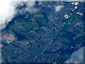
Wallsend from the air
Looking along the A1058 Coast Road from an Edinburgh bound flight from Prague.
Image: © Thomas Nugent
Taken: 18 Aug 2017
0.21 miles