IMAGES TAKEN NEAR TO
Nares Road, GILLINGHAM, ME8 9RQ
Introduction
This page details the photographs taken nearby to Nares Road, ME8 9RQ by members of the Geograph project.
The Geograph project started in 2005 with the aim of publishing, organising and preserving representative images for every square kilometre of Great Britain, Ireland and the Isle of Man.

There are currently over 7.5m images from over14,400 individuals and you can help contribute to the project by visiting https://www.geograph.org.uk
Image Map (Loading...)


Getting Data...Please wait
Leaflet Map data © OpenStreetMap
Images are licensed for reuse under creativecommons.org/licenses/by-sa/2.0
Notes
- Clicking on the map will re-center to the selected point.
- The higher the marker number, the further away the image location is from the centre of the postcode.
Image Listing (38 Images Found)
Images are licensed for reuse under creativecommons.org/licenses/by-sa/2.0
Image
Details
Distance
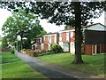
7
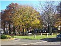
Peverel Green, Wigmore
Open land surrounded by houses, on Long Catlis Road.
Many nice trees.
Image: © David Anstiss
Taken: 12 Nov 2008
0.11 miles
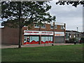
9
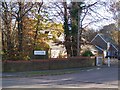
St Augustine's Catholic church, Park Wood
On Deanwood Drive, opposite Long Catlis Road.
Looks like a normal house, until Gable-end windows are seen.
Beside St Augustine of Canterbury Catholic Primary School, on left.
Image: © David Anstiss
Taken: 12 Nov 2008
0.12 miles