1
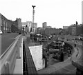
New ramp alongside GMEX, Manchester
Looking NE the piers for the ramp can be seen. This ramp will take the Metrolink tracks up onto the old viaduct leading south west from Manchester Central.
Image: © Dr Neil Clifton
Taken: 13 Oct 1990
0.00 miles
2
Going under Manchester Central
The arches under Manchester Central lead to underground car parks.
Image: © Gerald England
Taken: 14 Oct 2017
0.00 miles
3
Below Manchester central
This is the way into the car park built under the Manchester central exhibition stadium. On the left the arches date back to when this was the railway line and the hall was a station. On the right the modern equivalent erected for the tram system toward Piccadilly Gardens.
The small tower is part of the Midland Hotel.
Image: © Bob Harvey
Taken: 21 May 2017
0.01 miles
4
Metrolink Checkpoint, Lower Mosley Street
Due to the major improvement works being carried out at St Peter’s Square, Metrolink services through this area are restricted with single line working only possible through the square.
Trams are running in both directions over the outbound line, but not stopping in the square platform. A form of token working is being used. The driver must carry the token; unless there is to be more than one tram in the same direction, when he must be shown the token and given the authority to proceed. A temporary shelter has been erected to house the ‘signalman’ who controls the line.
Here, an inbound tram is approaching the checkpoint at the city end of the viaduct at Lower Mosley Street.
Image: © David Dixon
Taken: 20 Dec 2015
0.01 miles
5
Metrolink Tram passing Manchester Central
Metrolink tram number 3102 reaches Lower Moseley Street after descending from the Castlefield/Deansgate tram stop. It is travelling towards Manchester Victoria Station (probably on the route from Manchester Airport).
Image: © David Dixon
Taken: 18 Jan 2020
0.01 miles
6
Looking down the tram tracks at the towers of Manchester
On the left is the Bridgewater Hall. On the right is the Beetham Tower peering over the top of Manchester Central. Ahead are the Owen Street Towers on Deansgate Square and beyond them towers on the First Street development. In front of them is the Tower of Light.
Called the "Tower of Light", the tall, white structure is the chimney for a new energy project - the Civic Quarter Heat Network - which will power a number of prominent buildings including Central Library, the Bridgewater Hall, Heron House and the Manchester Art Gallery, by sending electricity and heat - via hot water - through two kilometres of underground pipes.
Image: © Gerald England
Taken: 27 May 2021
0.01 miles
7
Ornate Lamp at the Manchester Central (Formerly known as the GMEX centre and Manchester International Conference Centre (MICC)
Image: © Robert Wade
Taken: 10 Aug 2010
0.01 miles
8
Tram on Viaduct at Lower Mosley Street
Metrolink tram 3055 descends the viaduct between Deansgate-Castlefield and St Peter's Square.
Image: © David Dixon
Taken: 20 Dec 2015
0.01 miles
9
Below Manchester Central
On the right is Manchester Central Exhibition Centre. The road on the left leads into the underground car parks below the former station. Over the road is the Metrolink tramlines.
Image: © Gerald England
Taken: 14 Oct 2017
0.01 miles
10
Manchester Central, exhibition and convention centre
Formerly Manchester Central station, then used from the mid 1960s to the early 1980s as a car park, this building became a convention centre initially under the name G-MEX. Among events hosted here was 1986's Festival of the Tenth Summer, an event marking ten years since the Sex Pistols played at Manchester's Little Free Trade Hall and kick-started Manchester's punk and post-punk scene; most of the survivors of that scene played at the 1986 Festival. The site is now known as Manchester Central.
Image: © Christopher Hilton
Taken: 25 Oct 2010
0.01 miles


