IMAGES TAKEN NEAR TO
Robin Lane, LS29 6RZ
Introduction
This page details the photographs taken nearby to Robin Lane, LS29 6RZ by members of the Geograph project.
The Geograph project started in 2005 with the aim of publishing, organising and preserving representative images for every square kilometre of Great Britain, Ireland and the Isle of Man.

There are currently over 7.5m images from over14,400 individuals and you can help contribute to the project by visiting https://www.geograph.org.uk
Image Map (Loading...)


Getting Data...Please wait
Leaflet Map data © OpenStreetMap
Images are licensed for reuse under creativecommons.org/licenses/by-sa/2.0
Notes
- Clicking on the map will re-center to the selected point.
- The higher the marker number, the further away the image location is from the centre of the postcode.
Image Listing (63 Images Found)
Images are licensed for reuse under creativecommons.org/licenses/by-sa/2.0
Image
Details
Distance
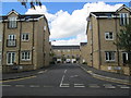
1

Hawksworth Drive - viewed from St Peter's Way
Image: © Betty Longbottom
Taken: 17 Apr 2013
0.04 miles


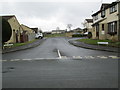
5

Menston Primary School - St Peter's Way
Image: © Betty Longbottom
Taken: 3 Aug 2013
0.10 miles
7
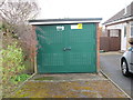
Electricity Substation No 4914 - Hawksworth Drive
Image: © Betty Longbottom
Taken: 17 Apr 2013
0.11 miles
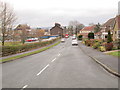
8
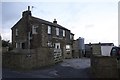
New House Farm
Sited in a commanding position on Bingley Road, Menston
Image: © Richard Kay
Taken: 23 Nov 2009
0.11 miles
9

Menston Primary School
Founded in 1894 as Menston Board School.
Image: © John Illingworth
Taken: 22 May 2007
0.12 miles