IMAGES TAKEN NEAR TO
Llandyfrydog, LLANNERCH-Y-MEDD, LL71 8AL
Introduction
This page details the photographs taken nearby to LL71 8AL by members of the Geograph project.
The Geograph project started in 2005 with the aim of publishing, organising and preserving representative images for every square kilometre of Great Britain, Ireland and the Isle of Man.

There are currently over 7.5m images from over14,400 individuals and you can help contribute to the project by visiting https://www.geograph.org.uk
Image Map (Loading...)


Getting Data...Please wait
Leaflet Map data © OpenStreetMap
Images are licensed for reuse under creativecommons.org/licenses/by-sa/2.0
Notes
- Clicking on the map will re-center to the selected point.
- The higher the marker number, the further away the image location is from the centre of the postcode.
Image Listing (6 Images Found)
Images are licensed for reuse under creativecommons.org/licenses/by-sa/2.0
Image
Details
Distance
1
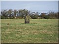
Bryn Dyfrydog Standing Stone.
Prehistoric Standing Stone.
Image: © Ray West
Taken: 7 Oct 2008
0.04 miles
3
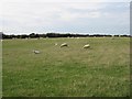
"I Eat Quickly"
Sheep alongside the road to Bryn Dyfrydog.
Image: © Roger Gilbertson
Taken: 27 Aug 2006
0.18 miles
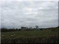
4
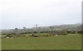
Wind Farm And Wires
As seen from the road to Bryn Dyfrydog.
Image: © Roger Gilbertson
Taken: 27 Aug 2006
0.18 miles
5
Maen Cwyf Stone
This flat stone could possibly have been a capstone of a prehistoric burial chamber.
Image: © Eric Jones
Taken: 28 Mar 2009
0.21 miles
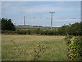
6
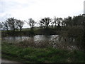
Pwll Du - a dark pool near Bryn Dyfrydog Crossroads
This area is dotted with small pools many being flooded quarries.
Image: © Eric Jones
Taken: 28 Mar 2009
0.23 miles