1
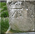
1GL benchmark & bolt at St. Madryn's Church, Trawsfynydd
This 1GL benchmark & bolt is located on the SE angle of St. Madryn's Church in Trawsfynydd and was used during the Ordnance Survey's First Primary Levelling on the line between Warrington and Pembroke Docks, between September 1851 and July 1852. This was mark No. 439 along this levelling line and was 771.7940ft above the Liverpool datum. The Ordnance Survey database shows that this mark was last verified in 1942.
Image: © Meirion
Taken: 21 Mar 2012
0.02 miles
2
Ordnance Survey 1GL Bolt
This OS Bolt can be found on the SE angle of St Madryn's Church. It marks a point 235.374m above mean sea level.
Image: © Adrian Dust
Taken: 11 May 2016
0.02 miles
3
Trawsfynydd Village Square
Cottages facing the church in Trawsfynydd.
Image: © Eirian Evans
Taken: 26 Apr 2009
0.02 miles
4
Mynwent Capel Salem Cemetery
Image: © Eric Jones
Taken: 23 Aug 2007
0.03 miles
5
St Madryn's Church, Trawsfynydd
The information panel gives information about the St John Roberts Trail, which commemorates the life and achievements of this son of Trawsfynydd. Tucked between the Rhinog and Moelwyn mountain ranges, the trail passes through one of the most extensive and best preserved Bronze Age landscapes in the country. The trail begins at the medieval St Madryn’s Church, Trawsfynydd, where St John Roberts is believed to have been baptised, then winds its way toward Cymer Abbey, near Dolgellau, where Roberts is thought to have received his early education.
St John Roberts was a Catholic priest executed for treason at Tyburn, Middlesex on 10th December 1610. Considered a martyr by the Catholic Church, Roberts became a staunch opponent of the Reformation after converting to Catholicism while visiting Notre Dame Cathedral in Paris. Sentenced to be hanged, drawn and quartered, he had shown such compassion to the poor of London that the crowd at this public spectacle turned on the executioners, insisting that Roberts be hanged until dead rather than being disembowelled alive as was the norm. A relic of his finger is kept at Gellilydan Church, not far from Trawsfynydd.
Image: © Eirian Evans
Taken: 26 Apr 2009
0.03 miles
6
Stryd y Capel (Chapel Street)
Leading up to the church, with the village hall on the left.
Image: © Eirian Evans
Taken: 26 Apr 2009
0.03 miles
7
Moreia - Capel Cydenwadol y Fro a Chofeb Hedd Wyn. Moriah Interdenominational Chapel and the Hedd Wyn Memorial
Image: © Eric Jones
Taken: 28 Jul 2007
0.03 miles
8
Lych Gate, St Madryn's Church
Image: © Eirian Evans
Taken: 26 Apr 2009
0.03 miles
9
St Madryn's Church, Trawsfynydd
The western gables of the church, and its bellcote.
Image: © Eirian Evans
Taken: 26 Apr 2009
0.03 miles
10
Moreia Chapel, Trawsfynydd
Standing proud in the centre of the village.
Image: © Eirian Evans
Taken: 26 Apr 2009
0.03 miles


