1
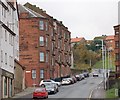
Disused school Inverkeithing
The former Inverkeithing primary school and in the distance the Forth Bridge
Image
Image: © Paul Mc Ilroy
Taken: 20 Feb 2007
0.06 miles
2
Former Inverkeithing Primary School
The former school was built in 1874 (juniors) and 1913 (seniors) and is situated on Roods Road.
Corporal Punishment ceased in Scottish state schools in 1986 but Fife Council have just allowed former Inverkeithing Primary School building to be flogged http://www.geograph.org.uk/discuss/index.php?action=vthread&topic=8732#1 at auction.
Image: © Simon Johnston
Taken: 7 Oct 2008
0.07 miles
3
Inverkeithing Primary School (Closed)
The school is now closed, boarded up and trying to be redeveloped as an industrial/storage unit. Often a night time hang out for the local youths.
Image: © Steve Barnes
Taken: 19 Mar 2010
0.08 miles
4
Inverkeithing
High Street. The town centre.
Image: © Simon Johnston
Taken: 18 Aug 2005
0.10 miles
5
Fordell's Lodging, Church Street
An L-plan tower house built by Sir John Henderson of Fordell in 1671. The Hendersons were hereditary provosts of the burgh.
Image: © kim traynor
Taken: 20 Apr 2011
0.11 miles
6
Hill Street Inverkeithing
Hill Street, as the name suggests, is on a steep hill, it connects Inverkeithing Square to Dunfermline Wynd. The large tenement building on the left is called Queen Mary Terrace.
Image: © Paul McIlroy
Taken: 18 Nov 2007
0.12 miles
7
Inverkeithing
New residential property under construction at the corner of Boreland Road and Church Street, where The Station Garage used to stand.
Image: © Paul McIlroy
Taken: 15 Jan 2007
0.12 miles
8
Inverkeithing Parish Kirk
The western tower of St. Peter's is the oldest part of the kirk, dating from the 14th century. The main part of the building is a neo-Gothic rebuild following a devastating fire in the 1820s.
Image: © kim traynor
Taken: 20 Apr 2011
0.13 miles
9
Tower of St. Peter's, Inverkeithing
Image: © kim traynor
Taken: 20 Apr 2011
0.13 miles
10
Fordell's Lodging
A Category A Listed building http://portal.historic-scotland.gov.uk/hes/web/f?p=PORTAL:DESIGNATION:::::DES:LB35103 on Church Street.
Image: © Thomas Nugent
Taken: 23 Dec 2015
0.13 miles


