IMAGES TAKEN NEAR TO
Wards Park, ORKNEY, KW17 2TS
Introduction
This page details the photographs taken nearby to Wards Park, KW17 2TS by members of the Geograph project.
The Geograph project started in 2005 with the aim of publishing, organising and preserving representative images for every square kilometre of Great Britain, Ireland and the Isle of Man.

There are currently over 7.5m images from over14,400 individuals and you can help contribute to the project by visiting https://www.geograph.org.uk
Image Map (Loading...)


Getting Data...Please wait
Leaflet Map data © OpenStreetMap
Images are licensed for reuse under creativecommons.org/licenses/by-sa/2.0
Notes
- Clicking on the map will re-center to the selected point.
- The higher the marker number, the further away the image location is from the centre of the postcode.
Image Listing (79 Images Found)
Images are licensed for reuse under creativecommons.org/licenses/by-sa/2.0
Image
Details
Distance
1
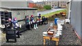
Odd ensemble, odd audience
Yard next to the bus stop in St Margaret's Hope. The pots and pans on the right are musical instruments and visitors are encouraged to play them. The fellows on the left are the cheerful, if somewhat silent, audience.
Image: © Aleks Scholz
Taken: 22 Jan 2020
0.03 miles
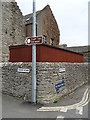
3
St Margaret's Hope
The point where Cromarty Square meets Pier Road (left) and Back Road (right), the pre-bypass main road through The Hope. The ferry from Gills Bay is just coming in. For those interested, the chip van stops here every Wednesday at 5 pm.
Image: © Bill Boaden
Taken: 7 Aug 2013
0.05 miles
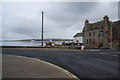
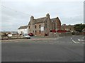
4
Cromarty Square, St Margaret's Hope
Cromarty Square is at the heart of this South Ronaldsay village - the third largest settlement in Orkney. The ferry terminal can be seen in the distance.
Image: © Stephen McKay
Taken: 12 Aug 2009
0.05 miles
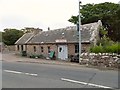
5
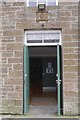
The Cromarty Hall, St Margaret's Hope
A community hall.
Image: © Richard Webb
Taken: 8 Apr 2018
0.06 miles
6

Pierside Paraphernalia
Mostly, but not quite all, related to catching shellfish. In the distance is the pier from which the ferry leaves for Gill's Bay in Caithness.
Image: © Anne Burgess
Taken: 10 Jun 2018
0.06 miles
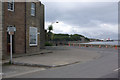
7

Beach, St Margaret's Hope
The ferry terminal is in the background.
Image: © Richard Webb
Taken: 8 Apr 2018
0.06 miles
8
Front Road meets Back Road
Pier Road is in the foreground - Front Road comes in from the left, Back Road from the right.
I don't know what the ship's propeller is doing there.
Image: © Antony Dixon
Taken: 9 Jul 2018
0.06 miles
9
Front Road and Back Road
Front Road is closer to the sea than Back Road, but Back Road is a through road.
Image: © Anne Burgess
Taken: 10 Jun 2018
0.07 miles
10
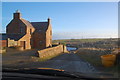
Bellevue and "the Hope"
Looking eastwards, downhill to St. Margaret's Hope.
Image: © Ian Balcombe
Taken: 10 Dec 2008
0.07 miles