IMAGES TAKEN NEAR TO
Ogden, HALIFAX, HX2 8YD
Introduction
This page details the photographs taken nearby to HX2 8YD by members of the Geograph project.
The Geograph project started in 2005 with the aim of publishing, organising and preserving representative images for every square kilometre of Great Britain, Ireland and the Isle of Man.

There are currently over 7.5m images from over14,400 individuals and you can help contribute to the project by visiting https://www.geograph.org.uk
Image Map (Loading...)


Getting Data...Please wait
Leaflet Map data © OpenStreetMap
Images are licensed for reuse under creativecommons.org/licenses/by-sa/2.0
Notes
- Clicking on the map will re-center to the selected point.
- The higher the marker number, the further away the image location is from the centre of the postcode.
Image Listing (11 Images Found)
Images are licensed for reuse under creativecommons.org/licenses/by-sa/2.0
Image
Details
Distance
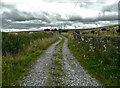
1
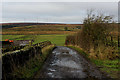
Access Track leading to New Moss Farm
Adopted by a footpath from the A629 at Causeway Foot.
Image: © Chris Heaton
Taken: 23 Nov 2016
0.03 miles
2
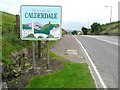
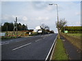
The Calderdale boundary, Halifax Road (A629)
Exactly on the watershed between Airedale and Calderdale. Next to the wall opposite the sign there is a defaced boundary stone where Ovenden (Halifax), Thornton and Denholme meet. For a close view of the stone see Image
Image: © Humphrey Bolton
Taken: 26 Aug 2010
0.18 miles
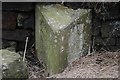
3
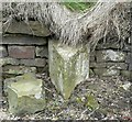
Boundary stone, Halifax Road (A629)
Where Ovenden (Halifax), Thornton and Denholme meet. Unfortunately it has been defaced. See also Image
Image: © Humphrey Bolton
Taken: 26 Aug 2010
0.18 miles
4
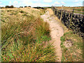
Back Lane, near Ogden
In some places like that shown here, the lane runs over the exposed sandstone bedrock.
Image: © David Spencer
Taken: 19 Aug 2005
0.20 miles
5
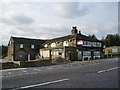
The Goose Inn, Keighley Road, Causeway Foot
Image: © Alexander P Kapp
Taken: 30 Oct 2008
0.21 miles
7
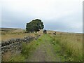
Bridleway approaching Peat Holes remains
Peat Holes appears to be an hill farm abandoned in the early part of the 20th century.
Image: © Kevin Waterhouse
Taken: 12 Aug 2024
0.23 miles
8
The two branches of Foreside Bottom Lane, Denholme
The branch to the left has a surface of loose grit and is a public footpath, whilsy the branch to the right is covered in grass and is a public beirdleway.
Image: © Humphrey Bolton
Taken: 27 Aug 2021
0.23 miles
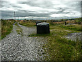
9
Old Boundary Marker by the A629, Denholme Gate, Halifax Road
Parish Boundary Marker by the A629, in parish of Halifax (Calderdale District), Denholme Gate, Halifax Road, beside low stone wall and modern Calderdale sign.
Surveyed
Milestone Society National ID: YW_HALI03pb.
Image: © Milestone Society
Taken: Unknown
0.23 miles
10
Foreside Bottom Lane, Denholme
This is a bridleway that comes to a halt after Allotments Farm. However there is a good bridleway to the left, passing the ruins of Royd Hall, to the Back Lane bridleway.
Image: © Humphrey Bolton
Taken: 27 Aug 2021
0.24 miles