IMAGES TAKEN NEAR TO
Woodfield Road, HARROGATE, HG1 4JT
Introduction
This page details the photographs taken nearby to Woodfield Road, HG1 4JT by members of the Geograph project.
The Geograph project started in 2005 with the aim of publishing, organising and preserving representative images for every square kilometre of Great Britain, Ireland and the Isle of Man.

There are currently over 7.5m images from over14,400 individuals and you can help contribute to the project by visiting https://www.geograph.org.uk
Image Map (Loading...)


Getting Data...Please wait
Leaflet Map data © OpenStreetMap
Images are licensed for reuse under creativecommons.org/licenses/by-sa/2.0
Notes
- Clicking on the map will re-center to the selected point.
- The higher the marker number, the further away the image location is from the centre of the postcode.
Image Listing (36 Images Found)
Images are licensed for reuse under creativecommons.org/licenses/by-sa/2.0
Image
Details
Distance
1
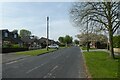
Woodfield Road
Looking along Woodfield Road near Poplar Way.
Image: © DS Pugh
Taken: 17 Apr 2022
0.03 miles
2
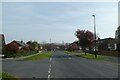
Woodfield Road and Poplar Crescent
Looking along Woodfield Road with Poplar Crescent to the left.
Image: © DS Pugh
Taken: 17 Apr 2022
0.06 miles
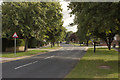
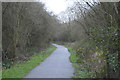
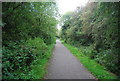
7

The Nidderdale Greenway near Bilton, Harrogate
Image: © habiloid
Taken: 14 Jan 2023
0.16 miles
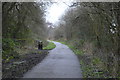
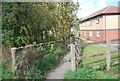
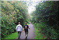
10
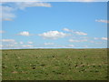
Field next to cycleway
Taken from the Bilton cycle path along the old railway line.
Image: © DS Pugh
Taken: 31 Mar 2006
0.17 miles