IMAGES TAKEN NEAR TO
Totland Close, FARNBOROUGH, GU14 8UA
Introduction
This page details the photographs taken nearby to Totland Close, GU14 8UA by members of the Geograph project.
The Geograph project started in 2005 with the aim of publishing, organising and preserving representative images for every square kilometre of Great Britain, Ireland and the Isle of Man.

There are currently over 7.5m images from over14,400 individuals and you can help contribute to the project by visiting https://www.geograph.org.uk
Image Map (Loading...)


Getting Data...Please wait
Leaflet Map data © OpenStreetMap
Images are licensed for reuse under creativecommons.org/licenses/by-sa/2.0
Notes
- Clicking on the map will re-center to the selected point.
- The higher the marker number, the further away the image location is from the centre of the postcode.
Image Listing (401 Images Found)
Images are licensed for reuse under creativecommons.org/licenses/by-sa/2.0
Image
Details
Distance
1
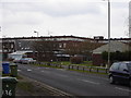
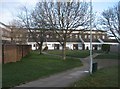
Flats off Mayfield Road
These flats are in an old London overspill estate.
Image: © Graham Clutton
Taken: 5 Jan 2006
0.00 miles

5
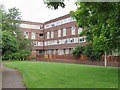
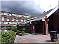
Totland Flats
Totland Flats, Totland close Farnborough
Image: © Craig
Taken: 14 Apr 2006
0.01 miles
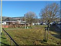

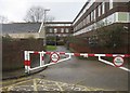
9
Farnborough Railway Station to Samuel Cody School (63)
Totland Supermarket, Mayfield Road
Image: © Basher Eyre
Taken: 1 Jul 2022
0.02 miles
10
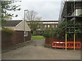
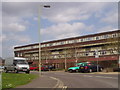
Doing up Totland Estate
A grim block of 167 flats, built in the seventies by the Greater London Council (GLC).
Image: © Fernweh
Taken: 29 Apr 2015
0.03 miles