IMAGES TAKEN NEAR TO
New Dawn Close, FARNBOROUGH, GU14 0PD
Introduction
This page details the photographs taken nearby to New Dawn Close, GU14 0PD by members of the Geograph project.
The Geograph project started in 2005 with the aim of publishing, organising and preserving representative images for every square kilometre of Great Britain, Ireland and the Isle of Man.

There are currently over 7.5m images from over14,400 individuals and you can help contribute to the project by visiting https://www.geograph.org.uk
Image Map (Loading...)


Getting Data...Please wait
Leaflet Map data © OpenStreetMap
Images are licensed for reuse under creativecommons.org/licenses/by-sa/2.0
Notes
- Clicking on the map will re-center to the selected point.
- The higher the marker number, the further away the image location is from the centre of the postcode.
Image Listing (18 Images Found)
Images are licensed for reuse under creativecommons.org/licenses/by-sa/2.0
Image
Details
Distance
2
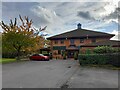
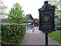
Crab & Anchor, Southwood
Autumn at the Crab & Anchor pub.
Image: © David Bremner
Taken: 1 Nov 2021
0.13 miles
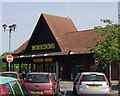
5
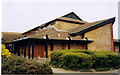
Morrison's supermarket, Southwood
The word village is a mistake. It's a bit of suburban sprawl. How many villages have shops this size?
Image: © Andrew Smith
Taken: 7 May 2006
0.14 miles
6
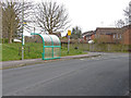
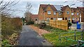
Southwood Lane, Cove
The bus stop on Southwood Lane by the entrance to the Morrison's car park.
Image: © Alan Hunt
Taken: 28 Mar 2014
0.15 miles
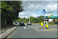
7
A327 Ively Road
Heading north and west on the A327's very indirect route to Reading.
Image: © Robin Webster
Taken: 22 Aug 2020
0.16 miles
8
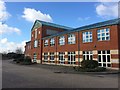
Unit at Southwood Business Park
No vehicles or signs of activity here!
Image: © don cload
Taken: 25 Feb 2016
0.17 miles
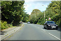
10
A327 Summit Avenue
Heading west, here, on the A327's very indirect route to Reading.
Image: © Robin Webster
Taken: 22 Aug 2020
0.17 miles