IMAGES TAKEN NEAR TO
Hesters Way Road, CHELTENHAM, GL51 0DT
Introduction
This page details the photographs taken nearby to Hesters Way Road, GL51 0DT by members of the Geograph project.
The Geograph project started in 2005 with the aim of publishing, organising and preserving representative images for every square kilometre of Great Britain, Ireland and the Isle of Man.

There are currently over 7.5m images from over14,400 individuals and you can help contribute to the project by visiting https://www.geograph.org.uk
Image Map (Loading...)


Getting Data...Please wait
Leaflet Map data © OpenStreetMap
Images are licensed for reuse under creativecommons.org/licenses/by-sa/2.0
Notes
- Clicking on the map will re-center to the selected point.
- The higher the marker number, the further away the image location is from the centre of the postcode.
Image Listing (14 Images Found)
Images are licensed for reuse under creativecommons.org/licenses/by-sa/2.0
Image
Details
Distance
1
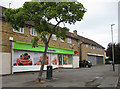
Hester's Way Post Office
And Co-operative shop. Hester's Way Road, Cheltenham.
Image: © Pauline E
Taken: 12 Jul 2008
0.09 miles
2
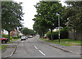
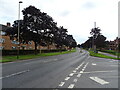
Barbridge Road
Running parallel to Princess Elizabeth Way.
Image: © Pauline E
Taken: 12 Jul 2008
0.12 miles
6
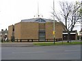
St Thomas More Church
A Roman Catholic Church on Princess Elizabeth Way.
Image: © Stephen Bowden
Taken: 23 Apr 2005
0.16 miles
8
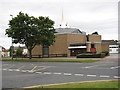
St Thomas More Catholic Church
On Princess Elizabeth Way, (A4013).
Image: © Pauline E
Taken: 12 Jul 2008
0.21 miles
9
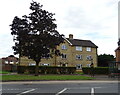
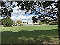
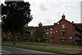
Flats on Princess Elizabeth Way (A4013), Cheltenham
Image: © JThomas
Taken: 9 Aug 2021
0.21 miles
10
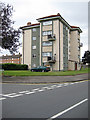
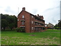
Five-storey block
On the junction of Orchard Way, Russet Road and Princess Elizabeth Way.
Image: © Pauline E
Taken: 12 Jul 2008
0.22 miles