IMAGES TAKEN NEAR TO
Court Farm Lane, MITCHELDEAN, GL17 0AY
Introduction
This page details the photographs taken nearby to Court Farm Lane, GL17 0AY by members of the Geograph project.
The Geograph project started in 2005 with the aim of publishing, organising and preserving representative images for every square kilometre of Great Britain, Ireland and the Isle of Man.

There are currently over 7.5m images from over14,400 individuals and you can help contribute to the project by visiting https://www.geograph.org.uk
Image Map (Loading...)


Getting Data...Please wait
Leaflet Map data © OpenStreetMap
Images are licensed for reuse under creativecommons.org/licenses/by-sa/2.0
Notes
- Clicking on the map will re-center to the selected point.
- The higher the marker number, the further away the image location is from the centre of the postcode.
Image Listing (96 Images Found)
Images are licensed for reuse under creativecommons.org/licenses/by-sa/2.0
Image
Details
Distance
1
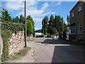
Court Farm Lane, Mitcheldean
The footpath heading off to the right is squeezed in between two houses.
Image: © Pauline E
Taken: 25 Aug 2007
0.02 miles
2
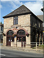
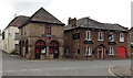
Town Hall, Mitcheldean
Listed Grade II.
Image: © Chris Allen
Taken: 28 Aug 2021
0.04 miles
3
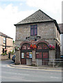
A small, but perfectly formed Town Hall
Built in 1710 at the junction of Townsend and Court Farm Lane.
Image: © Pauline E
Taken: 25 Aug 2007
0.04 miles
4
Town Hall next to the Pub
It's thirsty work being a councilor.
"The Town Hall building originally housed the office for the Wintle's Brewery (just along the road). That family owned business donated the land where the recreation ground is enabling that facility to be used by the people of the parish. The Town Hall was built in 1710 and houses the Parish Clerk's office and meeting room upstairs and a museum of early Xerox photocopiers on the ground floor." from Mitcheldean Parish Council's page.
Image: © Des Blenkinsopp
Taken: 8 Feb 2015
0.04 miles
5
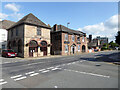
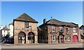
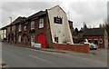
Old town Hall and The White Horse public house, Mitcheldean
Image: © Chris Allen
Taken: 28 Aug 2021
0.04 miles
6
Town hall and White Horse, Mitcheldean
Two centuries-old buildings in the centre of Mitcheldean. The town hall on the left shows the year 1710. One source states that The White Horse on the right was trading as early as 1674.
Image: © Jaggery
Taken: 24 Feb 2013
0.04 miles
7
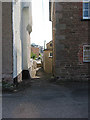
Short public footpath from Court Farm Lane
Image: © Pauline E
Taken: 25 Aug 2007
0.04 miles
8
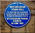
Town hall blue plaque, Mitcheldean
On the wall here. http://www.geograph.org.uk/photo/3854102
Image: © Jaggery
Taken: 24 Feb 2013
0.04 miles
9
White Horse, Mitcheldean
The High Street pub was formerly named the White Horse Hotel.
Image: © Jaggery
Taken: 24 Feb 2013
0.04 miles
10
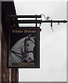
White Horse name sign, Mitcheldean
Located here. http://www.geograph.org.uk/photo/3854026
Image: © Jaggery
Taken: 24 Feb 2013
0.05 miles