1
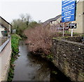
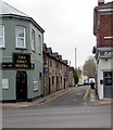
South along The Cut from Hill Street, Lydney
The Cut is the remains of the former Pidcock's Canal on which construction began in 1778.
A black & white sign on the right points the way to Lydney Town station on the Dean Forest Railway.
Image: © Jaggery
Taken: 15 Apr 2018
0.01 miles
2
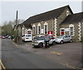
Lydney Christian Fellowship
Viewed across Swan Road, Lydney. Their website states that Lydney Christian Fellowship was established to actively evangelise the district by any and all means that are in harmony with scripture, to have both freedom and flexibility in worship, and to recognise and exercise all spiritual gifts as directed by the Holy Spirit.
Image: © Jaggery
Taken: 1 Jan 2013
0.01 miles
3
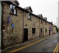
Lydney Christian Fellowship Church
Viewed across Swan Road. The church is on the east bank of a former canal, The Cut. https://www.geograph.org.uk/photo/5741401
Image: © Jaggery
Taken: 15 Apr 2018
0.01 miles
4
Christian Fellowship
Swan Road, Lydney
Image: © Pauline E
Taken: 11 Oct 2007
0.01 miles
5
Ugly Duckling Country Restaurant, Lydney
Viewed across Swan Road. The restaurant is adjacent to The Swan Hotel https://www.geograph.org.uk/photo/5739856
and occupies the area that was formerly The Swan's skittle alley.
https://www.geograph.org.uk/photo/5741146 to the name sign on the left.
Image: © Jaggery
Taken: 15 Apr 2018
0.01 miles
6
No parking in Swan Road, Lydney
Double yellow lines on both sides of the narrow one-way road indicate no parking at any time.
Image: © Jaggery
Taken: 15 Apr 2018
0.01 miles
7
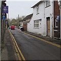
South along Swan Road, Lydney
Past the Swan Hotel and Zelish hair salon. Signs shows that Swan Road is one-way.
Image: © Jaggery
Taken: 15 Apr 2018
0.01 miles
8
Ugly Duckling Country Restaurant name sign, Lydney
Hanging from a wall bracket here. https://www.geograph.org.uk/photo/5741144
Image: © Jaggery
Taken: 15 Apr 2018
0.02 miles
9
Warning notice on the south side of Hill Street, Lydney
WARNING This is a PRIVATE CAR PARK for the use of WILDIN & CO clients and other people visiting KINGS BUILDINGS. There are CCTV cameras monitoring vehicles and people entering the site and any unauthorised vehicles will incur an immediate charge of £100 payable prior to exit.
Image: © Jaggery
Taken: 2 May 2021
0.02 miles
10
Rear entrance to shops in Regent's Walk, Lydney
Viewed from the corner of Regent Street.
Image: © Jaggery
Taken: 1 Jan 2013
0.02 miles


