IMAGES TAKEN NEAR TO
The Crapen, DURSLEY, GL11 6LP
Introduction
This page details the photographs taken nearby to The Crapen, GL11 6LP by members of the Geograph project.
The Geograph project started in 2005 with the aim of publishing, organising and preserving representative images for every square kilometre of Great Britain, Ireland and the Isle of Man.

There are currently over 7.5m images from over14,400 individuals and you can help contribute to the project by visiting https://www.geograph.org.uk
Image Map (Loading...)


Getting Data...Please wait
Leaflet Map data © OpenStreetMap
Images are licensed for reuse under creativecommons.org/licenses/by-sa/2.0
Notes
- Clicking on the map will re-center to the selected point.
- The higher the marker number, the further away the image location is from the centre of the postcode.
Image Listing (17 Images Found)
Images are licensed for reuse under creativecommons.org/licenses/by-sa/2.0
Image
Details
Distance
1
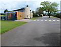
Cam Woodfield Infant and Junior Schools, Cam
Viewed from Elstub Lane.
Image: © Jaggery
Taken: 21 Jul 2012
0.02 miles
2
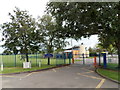
Entrance to Cam Woodfield Infant and Junior Schools, Cam
Viewed from Elstub Lane.
Image: © Jaggery
Taken: 21 Jul 2012
0.05 miles
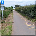
3
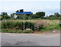
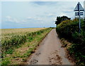
Elstub Lane signpost, Cam
The cycleway and footpath signpost shows left for The Quarry and Stinchcombe, right for Lower Cam and Draycott.
Image: © Jaggery
Taken: 21 Jul 2012
0.07 miles
4
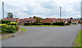
Bungalows on the corner of Tyndale Road and The Crapen, Cam
Viewed along Tyndale Road. The Crapen is on the left.
Image: © Jaggery
Taken: 21 Jul 2012
0.07 miles
5
Elstub Lane, Cam
This part of the lane, north of Tyndale Road, is not a through road for motor vehicles.
Image: © Jaggery
Taken: 21 Jul 2012
0.08 miles
6
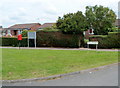
Postbox near The Crapen, Cam
The postbox is in a grass triangle on the corner of Elstub Lane and Tyndale Road.
A sign with arrows shows The Crapen, a nearby residential street.
Image: © Jaggery
Taken: 21 Jul 2012
0.08 miles
7
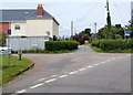
Crossroads in Cam
Viewed from The Quarry. Roads at or near this point are Westend, Field Lane, Elstub Lane and Tyndale Road. The blue sign arm pointing right shows Lower Cam and Draycott.
Image: © Jaggery
Taken: 21 Jul 2012
0.10 miles
8
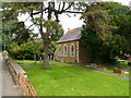
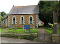
Side view of The Quarry URC, Cam
The Quarry United Reformed Church is located in The Quarry.
Image: © Jaggery
Taken: 21 Jul 2012
0.11 miles
9
Front view of The Quarry URC, Cam
The Quarry United Reformed Church viewed from a street named The Quarry.
Image: © Jaggery
Taken: 21 Jul 2012
0.11 miles
10
NE end of Elstub Lane, Cam
Out of shot ahead, Elstub Lane narrows to a path to Summerhayes.
Image: © Jaggery
Taken: 21 Jul 2012
0.12 miles