1
Early 21st century house, Gloucester Road, Standish near Stonehouse
House dated 2009 viewed across the B4008 Gloucester Road.
Image: © Jaggery
Taken: 16 Sep 2018
0.00 miles
2
Barn Nurseries car park, Standish near Stonehouse
Between the B4008 Gloucester Road and a polytunnel. Barn Nurseries sell bedding plants and shrubs.
Image: © Jaggery
Taken: 16 Sep 2018
0.01 miles
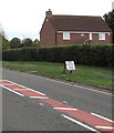
3
Entrance to Barn Nurseries in Standish near Stonehouse
From the B4008 Gloucester Road. The sign on the left shows that Barn Nurseries sell bedding plants and shrubs.
Image: © Jaggery
Taken: 16 Sep 2018
0.02 miles
4
Stroud Green Farm
Viewed across the B4008 Gloucester Road in the hamlet of Stroud Green
in the civil parish of Standish, north of Stonehouse.
Image: © Jaggery
Taken: 23 Dec 2012
0.02 miles
5
Stocks Barn, Gloucester Road, Standish near Stonehouse
Former barn converted to residential use viewed across the B4008 Gloucester Road.
Image: © Jaggery
Taken: 16 Sep 2018
0.04 miles
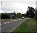
6
Gloucester Road from Standish towards Stonehouse
Looking south towards a bend in the B4008 Gloucester Road.
Image: © Jaggery
Taken: 16 Sep 2018
0.05 miles
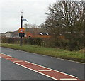
7
Reduce Speed Now, Gloucester Road, Standish
The sign faces northbound traffic on the approach to a bend in the B4008 Gloucester Road.
Image: © Jaggery
Taken: 16 Sep 2018
0.06 miles
8
The Malthouse, Stroud Green
The house is at the southern edge of the hamlet of Stroud Green in the civil parish of Standish,
north of Stonehouse. Viewed across the B4008 Gloucester Road.
Image: © Jaggery
Taken: 23 Dec 2012
0.06 miles
9
House by the B4008
Dwelling by the B4008 at Stroud Green.
Image: © Wayland Smith
Taken: 18 Sep 2020
0.06 miles
10
A green traffic sign, Stroud Green
Viewed across the B4008 Gloucester Road. The SLOW DOWN display
is powered by a combination of solar power and wind power.
Image: © Jaggery
Taken: 23 Dec 2012
0.09 miles


