IMAGES TAKEN NEAR TO
New Road, BIDEFORD, EX39 2BW
Introduction
This page details the photographs taken nearby to New Road, EX39 2BW by members of the Geograph project.
The Geograph project started in 2005 with the aim of publishing, organising and preserving representative images for every square kilometre of Great Britain, Ireland and the Isle of Man.

There are currently over 7.5m images from over14,400 individuals and you can help contribute to the project by visiting https://www.geograph.org.uk
Image Map (Loading...)


Getting Data...Please wait
Leaflet Map data © OpenStreetMap
Images are licensed for reuse under creativecommons.org/licenses/by-sa/2.0
Notes
- Clicking on the map will re-center to the selected point.
- The higher the marker number, the further away the image location is from the centre of the postcode.
Image Listing (660 Images Found)
Images are licensed for reuse under creativecommons.org/licenses/by-sa/2.0
Image
Details
Distance
1
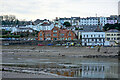
Bideford Police Station
Viewed across the R. Torridge from East-the-Water.
Image: © John Lucas
Taken: 8 Feb 2023
0.00 miles
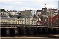
2

Bideford Police Station
The building to the right with scaffold erected was part of the Tantons Hotel. The arch is the second in from the Bideford end. There are 24 arches in Bideford Long Bridge.
Image: © Roger A Smith
Taken: 20 May 2020
0.01 miles
3
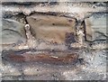
Ordnance Survey Cut Mark
This very worn OS cut mark can be found on the wall below the Police Station. It marks a point 5.834m above mean sea level.
Image: © Adrian Dust
Taken: 5 Dec 2019
0.01 miles
5
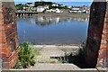
Access to the river known as Binney's Slip
See also: Image
Image: © Roger A Smith
Taken: 25 Jun 2010
0.02 miles
6
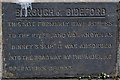
A plaque by the side of Binney's Slip on New Road
See also: Image
Image: © Roger A Smith
Taken: 25 Jun 2010
0.02 miles
7
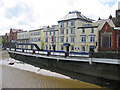
Hotel with view over the River Torridge
Viewed from Bideford Long Bridge.
Image: © Pauline E
Taken: 17 May 2009
0.03 miles
8
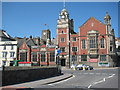
Bideford Town Hall
Bideford Town Hall is located at the junction of New Road and The Quay at the western end of Bideford Long Bridge.
Image: © Philip Halling
Taken: 11 Jun 2009
0.03 miles
9
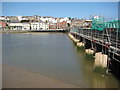
View across the Torridge, Bideford
View across the River Torridge in Bideford to buildings on New Road, including the red-brick ornate Town Hall. Bideford Long Bridge is on the right currently undergoing repair work.
Image: © Philip Halling
Taken: 11 Jun 2009
0.03 miles
10

Ordnance Survey Cut Mark
This OS cut mark can be found on the wall adjacent to No21 Lower Meddon Street. It marks a point 15.734m above mean sea level.
Image: © Adrian Dust
Taken: 13 Jul 2015
0.03 miles