IMAGES TAKEN NEAR TO
Commercial Road, EXETER, EX2 4EF
Introduction
This page details the photographs taken nearby to Commercial Road, EX2 4EF by members of the Geograph project.
The Geograph project started in 2005 with the aim of publishing, organising and preserving representative images for every square kilometre of Great Britain, Ireland and the Isle of Man.

There are currently over 7.5m images from over14,400 individuals and you can help contribute to the project by visiting https://www.geograph.org.uk
Image Map (Loading...)


Getting Data...Please wait
Leaflet Map data © OpenStreetMap
Images are licensed for reuse under creativecommons.org/licenses/by-sa/2.0
Notes
- Clicking on the map will re-center to the selected point.
- The higher the marker number, the further away the image location is from the centre of the postcode.
Image Listing (1024 Images Found)
Images are licensed for reuse under creativecommons.org/licenses/by-sa/2.0
Image
Details
Distance
1
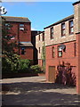
Weaver's Court, Exeter
Modern housing on Shilhay, built in the late 1970's on land beside the River Exe. Until flood prevention was put in place in the 60s and 70s, residential development here would have been difficult.
Image: © Derek Harper
Taken: 25 Sep 2006
0.01 miles
2

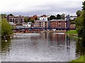
Buildings on Exeter Quay from above
Taken looking down from the pathway beside the city walls (to the right). The side of the Customs House is on the right; Cricklepit Bridge is beyond the warehouse; and the Haven Banks flats are on the left over the river. Beyond is St Thomas.
Image: © Derek Harper
Taken: 10 Oct 2006
0.01 miles
3
River Exe, Cricklepit Bridge
This footbridge across the River Exe was built in 1988 to link the quayside with Haven Banks. Photo from Haven Bank.
Image: © David Dixon
Taken: 14 Aug 2009
0.01 miles
4

Exeter: Old Warehouses by the Quay
These buildings were two clubs and a restaurant on the quay, called Tiffany's and Mambo. The clubs have now closed. Even earlier in the mid-1960s, the building was called The Quay Club. In the late 1960s it was host to the Radio One Club.
Image: © Mr Eugene Birchall
Taken: 8 Apr 2010
0.01 miles
5
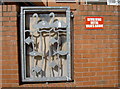
Watch out above!
An incongruous sign on a wall in Commercial Road, but with no obvious moving parts apparent. The metal feature seems of no relevance.
Image: © Neil Owen
Taken: 20 Aug 2014
0.02 miles
6
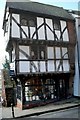
The House that Moved in Exeter
The House that Moved is at Stepcote Hill beside St Mary Steps Church, Exeter. It is a small timber-framed house dating from 1471, one room wide but three storeys high. It created a bit of a sensation when it was threatened by road expansion in 1961. Rather than demolish it they decided to move it! It was put on rollers and moved to its current location, some 70 metres (75 yards) from the original place.
Image: © Anthony Volante
Taken: 26 Feb 2010
0.02 miles
7

Swans by Cricklepit footbridge
See Image; the swans have moved onto the neighbouring grass.
Image: © Derek Harper
Taken: 22 Oct 2009
0.02 miles
8

Converted store buildings in Commercial Street, off Exeter Quay
Image: © David Gearing
Taken: 7 Apr 2010
0.03 miles
9

Former warehouse, Commercial Road, Exeter
It bears the words, "Kennaway & Co Limited / Bonded Stores" and is dated 1892. Listed "because it has an unusually lavish show front with good architectural detail". (Pity I turned up during a commercial vehicle convention.) Grade II listed.
It was a restaurant at the time, but has since been converted into seven flats.
Image: © Stephen Richards
Taken: 18 Jun 2014
0.03 miles
10

The X-Centre, Exeter
A fuller view of Image, which has a description. Seen from across Commercial Road.
Image: © Derek Harper
Taken: 6 Mar 2007
0.03 miles