IMAGES TAKEN NEAR TO
West Putford, HOLSWORTHY, EX22 7UF
Introduction
This page details the photographs taken nearby to EX22 7UF by members of the Geograph project.
The Geograph project started in 2005 with the aim of publishing, organising and preserving representative images for every square kilometre of Great Britain, Ireland and the Isle of Man.

There are currently over 7.5m images from over14,400 individuals and you can help contribute to the project by visiting https://www.geograph.org.uk
Image Map (Loading...)


Getting Data...Please wait
Leaflet Map data © OpenStreetMap
Images are licensed for reuse under creativecommons.org/licenses/by-sa/2.0
Notes
- Clicking on the map will re-center to the selected point.
- The higher the marker number, the further away the image location is from the centre of the postcode.
Image Listing (9 Images Found)
Images are licensed for reuse under creativecommons.org/licenses/by-sa/2.0
Image
Details
Distance
1

Riverside Cottage, West Putford
This attractive thatched cottage is just over the bridge at the bottom of the hill leading up to West Putford school.
Image: © Dave Sellers
Taken: 14 Feb 2008
0.02 miles


5
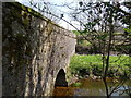
Putford Bridge as seen from downstream
Image: © Roger A Smith
Taken: 22 Apr 2010
0.05 miles
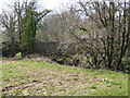
6
The view downstream from Putford Bridge
Image: © Roger A Smith
Taken: 22 Apr 2010
0.06 miles
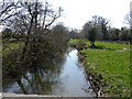
7
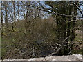
The view upstream from Putford Bridge
Image: © Roger A Smith
Taken: 22 Apr 2010
0.07 miles
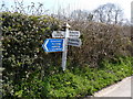
8

Putford Bridge
The bridge can just be seen as the road goes round to the left, the junction to the right leads to East Putford.
Image: © Dave Sellers
Taken: 14 Feb 2008
0.07 miles