IMAGES TAKEN NEAR TO
Bridgerule, HOLSWORTHY, EX22 7ED
Introduction
This page details the photographs taken nearby to EX22 7ED by members of the Geograph project.
The Geograph project started in 2005 with the aim of publishing, organising and preserving representative images for every square kilometre of Great Britain, Ireland and the Isle of Man.

There are currently over 7.5m images from over14,400 individuals and you can help contribute to the project by visiting https://www.geograph.org.uk
Image Map (Loading...)


Getting Data...Please wait
Leaflet Map data © OpenStreetMap
Images are licensed for reuse under creativecommons.org/licenses/by-sa/2.0
Notes
- Clicking on the map will re-center to the selected point.
- The higher the marker number, the further away the image location is from the centre of the postcode.
Image Listing (5 Images Found)
Images are licensed for reuse under creativecommons.org/licenses/by-sa/2.0
Image
Details
Distance
1
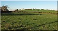
Field at Bevill's Hill
Looking left from where Image] was taken, with Tackbear Road on the left, following the telegraph poles.
Image: © Derek Harper
Taken: 19 Jan 2017
0.13 miles
2
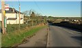
B3254 at Bevill's Hill
The hamlet ahead is Merrifield. Image] looks left from here.
Image: © Derek Harper
Taken: 19 Jan 2017
0.17 miles
3

Old Boundary Marker by the B3254, Bevill's Hill, Bridgerule parish
County Boundary Marker by the B3254, in parish of Bridgerule (Torridge District), Bevill's Hill, at junction with Tackbear Road, on verge by telegraph pole and drive to cottage.
Painted inscription reads vertically:-
: DEVON : : CORNWALL :
Cornwall & Scilly HER.
HER Number: MCO56546 https://www.heritagegateway.org.uk/Gateway/Results_Single.aspx?uid=MCO56546&resourceID=1020
Surveyed
Milestone Society National ID: DV_DVCW01cb
Image: © Milestone Society
Taken: Unknown
0.18 miles
4

Welcome to Cornwall
The B3254 road between Kilkhampton and Launceston enters Devon for just over a mile near Bridgerule. Here we re-enter Cornwall just south of Bevill's Hill.
Image: © Peter Kazmierczak
Taken: 12 Aug 2010
0.19 miles
5
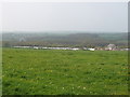
Hedley Wood Caravan and Camping Park
The caravan park http://www.hedleywood.co.uk/ nestles into the hillside so it is only just visible. View from Tackbear Road, which at this point is the county boundary with Devon to the north.
Image: © David Hawgood
Taken: 16 Apr 2007
0.24 miles