IMAGES TAKEN NEAR TO
St. Catherines Road, BROXBOURNE, EN10 7LB
Introduction
This page details the photographs taken nearby to St. Catherines Road, EN10 7LB by members of the Geograph project.
The Geograph project started in 2005 with the aim of publishing, organising and preserving representative images for every square kilometre of Great Britain, Ireland and the Isle of Man.

There are currently over 7.5m images from over14,400 individuals and you can help contribute to the project by visiting https://www.geograph.org.uk
Image Map (Loading...)


Getting Data...Please wait
Leaflet Map data © OpenStreetMap
Images are licensed for reuse under creativecommons.org/licenses/by-sa/2.0
Notes
- Clicking on the map will re-center to the selected point.
- The higher the marker number, the further away the image location is from the centre of the postcode.
Image Listing (93 Images Found)
Images are licensed for reuse under creativecommons.org/licenses/by-sa/2.0
Image
Details
Distance
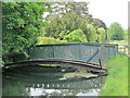
1
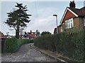
St Catharine's Estate
This road leads in from the footbridge across the New River.
Image: © Chris Brown
Taken: 31 Jan 2019
0.06 miles
2
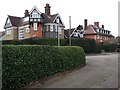
St Catharine's
Two contrasting houses on the eastern section of St Catharine's Road, both designed by Reginald Blomfield. The nearer, St Catharine's, is now a care home. The semi-detached pair in William-and-Mary style beyond, dating from 1894, is Grade 2 listed.
Image: © Chris Brown
Taken: 31 Jan 2019
0.07 miles
3
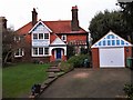
Bournebury, Osborne Road, St Catharine's estate
Facing the Spitalbrook at the southern junction of the estate is this prettiest of its houses.
Image: © Chris Brown
Taken: 31 Jan 2019
0.07 miles
4
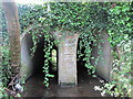
Spital Brook where it runs beneath the New River
Image: © Mike Quinn
Taken: 27 May 2015
0.08 miles
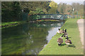
5
The New River where it crosses over Spital Brook
See Image
Image: © Mike Quinn
Taken: 27 May 2015
0.08 miles
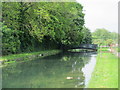
6
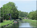
New River, Broxbourne
Canada geese strut around the bank of this 17th century water channel, built to supply London with Hertfordshire water.
Image: © Stephen McKay
Taken: 28 Mar 2011
0.09 miles
7
Dredging the New River, Broxbourne, Hertfordshire
Image: © Christine Matthews
Taken: 1 Jul 2011
0.09 miles
8

The New River east of St. Catharine's Road, EN10 (2)
Image: © Mike Quinn
Taken: 27 May 2015
0.09 miles
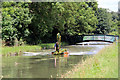
9
Footbridge over the New River north of Spital Brook
See Image
Image: © Mike Quinn
Taken: 27 May 2015
0.09 miles
10
The New River north of Broxbourne station
See Image
Image: © Mike Quinn
Taken: 27 May 2015
0.09 miles