1
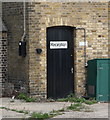
Former engine house, Myddelton Passage
Buildings associated with New River Head. The former engine and pump house, dated 1768, is on the left (opposite C19th workshops). Beyond is the remains of the old windmill of 1708. Grade II listed.
Image: © Stephen Richards
Taken: 11 Apr 2019
0.02 miles
2
Benchmark on New River Head Pump House
The Ordnance Survey cut mark benchmark can be seen on 4th and 5th bricks above ground on the corner to the left of the door. Additional details may be found at http://www.bench-marks.org.uk/bm39312
Image: © Roger Templeman
Taken: 27 Aug 2011
0.02 miles
3
Pump House off Amwell Street
There is an OS benchmark
Image on the corner to the left of the small black door.
Image: © Roger Templeman
Taken: 27 Aug 2011
0.02 miles
4
New River Head engine house, Islington
Grade II listed building, described at this https://historicengland.org.uk/listing/the-list/list-entry/1195724.
Image: © Jim Osley
Taken: 23 Oct 2016
0.02 miles
5
The (former) Pump House, New River Head
The pump house was built in 1768 to house a steam engine that was used to pump water from the Round Pond up to the Upper Pond (now the Claremont Square reservoir - see
Image). For further info, see http://www.british-history.ac.uk/survey-london/vol47/pp165-184 .
Image: © Mike Quinn
Taken: 17 Dec 2014
0.02 miles
6
New River Head
With
Image on the left and
Image beyond. The structure in the foreground is a shaft down to the London Ring Main - a major part of London's water supply infrastructure, consisting of approximately 50 miles of mostly 100 inch concrete pipelines used to transfer potable water from water treatment works in the Thames and River Lea catchments for distribution within London. For further info see http://en.wikipedia.org/wiki/Thames_Water_Ring_Main .
Image: © Mike Quinn
Taken: 17 Dec 2014
0.02 miles
7
River Street, EC1
The end house in the terrace (on the south side of the street) seems to have been added after the rest of the houses were built. It's much narrower than all the other houses, and although the (narrow) door and window on the ground floor have semi-circular tops like the other houses, the window in the first floor doesn't have the characteristic arch above, and the window in the second floor is also different from those in the rest of the terrace.
Image: © Mike Quinn
Taken: 17 Dec 2014
0.02 miles
8
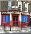
Lloyd's Dairy - at the corner of River Street and Amwell Street, EC1
'Dairy Farmers', 'First Class Dairy Produce'.
In one of George Sturt's memoirs of Surrey life in the mid-1800's, I read about Welsh drovers who led their herds through southern England at a certain time of year. Village schoolchildren (Sturt included) looked forward to this spectacle, and would stand on their chairs to watch the herds pass by. Many of the cattle were on their way to Channel ports.
My own memory - from the days before supermarkets - is that small local dairies in London often had Welsh names. Where I lived there was a "Morgan's". Sturt's reminiscence left me wondering how often Welsh drovers settled down with a girl they'd met along the way.
The name of the old dairy in EC1 is Lloyd's - a mere scrap of evidence for the theory I'm hinting at, but every little helps.
As for Lloyd' s being 'Dairy Farmers', I believe that in London dairy cattle were kept in yards up until about 1900.
Image: © Stefan Czapski
Taken: 17 Oct 2021
0.02 miles
9
Old wind pump base and pump house, New River Head
Both the round building and the one behind and to the left are grade II listed. The round one is the base of a wind pump, built about 1708, around 100 years after the New River was completed, to pump water up to a higher level reservoir to improve water distribution around London. It seems to have been unsatisfactory, and was replaced around 1720 by horse gins until the age of steam kicked in. In 1768 power for pumping was taken over by a steam engine housed in the large building. The engine was replaced and the building altered over the years, it no longer houses any machinery.
Image: © Robin Webster
Taken: 21 Mar 2013
0.03 miles
10
River Street, EC1 (2)
Terrace on the north side of the street, which is named after the New River http://en.wikipedia.org/wiki/New_River_(England) . See also
Image
Image: © Mike Quinn
Taken: 19 Nov 2014
0.03 miles


