1
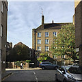
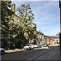
Corner of Wapping Dock Street and Cinnamon Street, Wapping
The materials of old Wapping are all here: London stock brick, hard-wearing stone, glass, iron.
Image: © Robin Stott
Taken: 13 Oct 2018
0.00 miles
2
Wapping Lane, London E1
Image: © Stacey Harris
Taken: 29 May 2010
0.01 miles
3
Junction of Wapping Dock Street with Cinnamon Street, Wapping
Here are the forerunners of warehouses converted to apartments – five-storey flats in London stock brick, a material that unifies the area visually. They were outlined on an OS map of 1938: they were present on a map of 1948-49.
Image: © Robin Stott
Taken: 13 Oct 2018
0.01 miles
4
View west across Cinnamon Street, Wapping
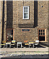
The building on the left is Columbus House: council-built flats over shops. They were outlined on an OS map of 1938: they were present on a map of 1948-49. The corner shop is a café. The road surface is of patched, mixed setts.
Image: © Robin Stott
Taken: 13 Oct 2018
0.01 miles
5
Tables and chairs outside Columbus House, Cinnamon Street, Wapping
For some reason no-one was sitting outside the Cinnamon coffee shop at this moment on a Saturday afternoon.
Image: © Robin Stott
Taken: 13 Oct 2018
0.01 miles
6
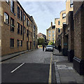
Northwest on Wapping Dock Street, Wapping
Cinnamon Street crosses it ahead. Wapping Overground station is behind the camera. Warehouses are now apartments, joining the many local authority flats to make Wapping a residential area.
Image: © Robin Stott
Taken: 13 Oct 2018
0.02 miles
7
White Swan & Cuckoo, Wapping
Image: © Chris Whippet
Taken: 10 Sep 2014
0.02 miles
8
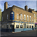
The White Swan & Cuckoo, Wapping Lane, Wapping
These buildings were outlined on an OS map of 1938: they were present on a map of 1948-49.
Image: © Robin Stott
Taken: 13 Oct 2018
0.02 miles
9
Northeast on Cinnamon Street, Wapping
Five-storey brick council-built flats on the left. They were outlined on an OS map of 1938: they were present on a map of 1948-49.
Image: © Robin Stott
Taken: 13 Oct 2018
0.02 miles
10
Transport for London/Santander bikes for hire, Wapping Lane, Wapping
People were out on bikes on a sunny Saturday afternoon in October. Entrance to Pizza Express on the left. The turning on the left is Green Bank. There are some shops beyond it. The turning on the right is Prusom Street.
Image: © Robin Stott
Taken: 13 Oct 2018
0.03 miles


