IMAGES TAKEN NEAR TO
Hawthorne Court, RETFORD, DN22 7WH
Introduction
This page details the photographs taken nearby to Hawthorne Court, DN22 7WH by members of the Geograph project.
The Geograph project started in 2005 with the aim of publishing, organising and preserving representative images for every square kilometre of Great Britain, Ireland and the Isle of Man.

There are currently over 7.5m images from over14,400 individuals and you can help contribute to the project by visiting https://www.geograph.org.uk
Image Map (Loading...)


Getting Data...Please wait
Leaflet Map data © OpenStreetMap
Images are licensed for reuse under creativecommons.org/licenses/by-sa/2.0
Notes
- Clicking on the map will re-center to the selected point.
- The higher the marker number, the further away the image location is from the centre of the postcode.
Image Listing (61 Images Found)
Images are licensed for reuse under creativecommons.org/licenses/by-sa/2.0
Image
Details
Distance
1
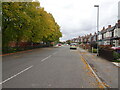
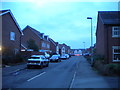
Early autumn on Ollerton Road, Retford
Image: © Nigel Thompson
Taken: 2 Oct 2020
0.08 miles
2
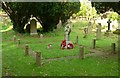
Ordsall War Memorial
In the churchyard. Unusually for a village war memorial, this dates from the period after the Second World War, being installed in 1951 “IN PROUD REMEMBRANCE OF THOSE WHO DID NOT RETURN” from both World Wars. It follows the form of a St Columba's cross, in granite. Listed Grade II in 2014.
Image: © Alan Murray-Rust
Taken: 11 Oct 2015
0.10 miles
4
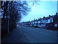
Ollerton Road, Ordsall (1)
Seen from the junction with Grace Road.
Image: © Richard Vince
Taken: 13 Jan 2018
0.12 miles
5
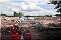
Once a factory now being demolished for house building
Image: © roger geach
Taken: 2 Aug 2008
0.12 miles
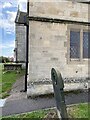
6
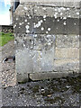
OS Cut Mark - Ordsall, All Hallows Church
https://www.bench-marks.org.uk/bm29487
Image: © thejackrustles
Taken: 11 Oct 2021
0.13 miles
7
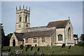
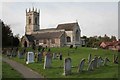
All Hallows church
Mostly 14th century church at Ordsall with 13th century arcades
Image: © Richard Croft
Taken: 1 Sep 2010
0.13 miles
8
Grace Road, Ordsall
Judging by the names of other roads in this development, this one is named after the home ground of Leicestershire County Cricket Club. Seen from Ollerton Road.
Image: © Richard Vince
Taken: 13 Jan 2018
0.13 miles
9
Location of OS Cut Mark - Ordsall, All Hallows Church
https://www.bench-marks.org.uk/bm29487
Image: © thejackrustles
Taken: 11 Oct 2021
0.13 miles
10
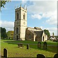
Church of All Hallows, Ordsall
View from the south west.
Image: © Alan Murray-Rust
Taken: 11 Oct 2015
0.14 miles