IMAGES TAKEN NEAR TO
Anderton Road, COVENTRY, CV6 6JQ
Introduction
This page details the photographs taken nearby to Anderton Road, CV6 6JQ by members of the Geograph project.
The Geograph project started in 2005 with the aim of publishing, organising and preserving representative images for every square kilometre of Great Britain, Ireland and the Isle of Man.

There are currently over 7.5m images from over14,400 individuals and you can help contribute to the project by visiting https://www.geograph.org.uk
Image Map (Loading...)


Getting Data...Please wait
Leaflet Map data © OpenStreetMap
Images are licensed for reuse under creativecommons.org/licenses/by-sa/2.0
Notes
- Clicking on the map will re-center to the selected point.
- The higher the marker number, the further away the image location is from the centre of the postcode.
Image Listing (15 Images Found)
Images are licensed for reuse under creativecommons.org/licenses/by-sa/2.0
Image
Details
Distance
1
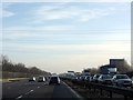
Power Lines Cross The M6 Motorway
A large queue had formed on the northbound carriageway due to an accident between junctions 3 and 3a.
Image: © Peter Whatley
Taken: 28 Dec 2009
0.14 miles
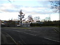
2
Anderton Road turning circle, Victoria Farm
As National Express Coventry route 6A does a one way loop around Victoria Farm estate, this turning circle is no longer used to turn buses, though they often wait here as it is the nominal terminus of the route.
Image: © Richard Vince
Taken: 10 Nov 2012
0.14 miles
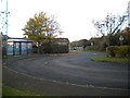
4
Turning circle on Ansell Drive, Victoria Farm
Although it does not appear to contain a bus stop, it appears possible that this turning circle may be used by school buses to Foxford School, outside whose entrance it is located.
Image: © Richard Vince
Taken: 10 Nov 2012
0.17 miles
5
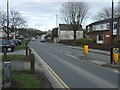
Alderman's Green Road (B4109)
Looking north east.
Image: © JThomas
Taken: 4 Mar 2017
0.18 miles
6
Aldermans Green Post Office
Showing position of Postbox No. CV2 165.
See Image] for postbox.
Image: © JThomas
Taken: 4 Mar 2017
0.18 miles
7
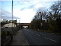
Grange Road north of Victoria Farm estate
Looking towards Hawkesury (which is beyond the Coventry city boundary) from the northern fringe of Victoria Farm estate. The bridge in the distance carries the M6 as it skirts the northern edge of Coventry.
Image: © Richard Vince
Taken: 10 Nov 2012
0.19 miles
8
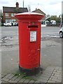
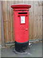
George VI postbox outside Aldermans Green Post Office
Postbox No. CV2 165.
See Image] for context.
Image: © JThomas
Taken: 4 Mar 2017
0.19 miles
9
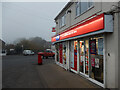
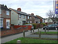
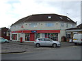
Alderman's Green Post Office
The post office and One Stop convenience store, at the junction of Alderman's Green Road and Canberra Road, looks welcoming on this murky morning.
Image: © Stephen McKay
Taken: 16 Nov 2021
0.19 miles
10
Elizabeth II postbox on Grange Road
Postbox No. CV6 110.
See Image] for context.
Image: © JThomas
Taken: 4 Mar 2017
0.20 miles