IMAGES TAKEN NEAR TO
Alveston, STRATFORD-UPON-AVON, CV37 7RP
Introduction
This page details the photographs taken nearby to CV37 7RP by members of the Geograph project.
The Geograph project started in 2005 with the aim of publishing, organising and preserving representative images for every square kilometre of Great Britain, Ireland and the Isle of Man.

There are currently over 7.5m images from over14,400 individuals and you can help contribute to the project by visiting https://www.geograph.org.uk
Image Map (Loading...)


Getting Data...Please wait
Leaflet Map data © OpenStreetMap
Images are licensed for reuse under creativecommons.org/licenses/by-sa/2.0
Notes
- Clicking on the map will re-center to the selected point.
- The higher the marker number, the further away the image location is from the centre of the postcode.
Image Listing (6 Images Found)
Images are licensed for reuse under creativecommons.org/licenses/by-sa/2.0
Image
Details
Distance
1
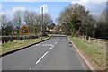
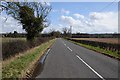
Loxley Road
Loxley Road passing Alveston Pasture Cottages.
Image: © Philip Halling
Taken: 16 Mar 2018
0.07 miles
2
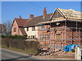
Alveston Pasture Cottages
The cottages beside the Loxley - Stratford-upon-Avon road have been much extended and modernised.
Image: © David Stowell
Taken: 10 Feb 2006
0.08 miles
3
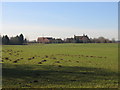
Alveston Pastures
Looking west along the southern edge of the square with Alveston Pastures in the trees, and a rampant outbreak of molehills in the foreground!
Image: © David Stowell
Taken: 10 Feb 2006
0.10 miles
4
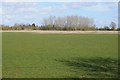
Farmland near Lower Hunscote Farm
Farmland near Lower Hunscote Farm viewed from Loxley Road.
Image: © Philip Halling
Taken: 16 Mar 2018
0.20 miles
5
Stratford Road
Stratford Road, a minor unclassified road to the west of Loxley.
Image: © Philip Halling
Taken: 16 Mar 2018
0.24 miles
6
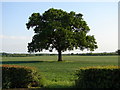
Tree With a View
Standing in a field near Alveston pastures, this proud oak deserves its own viewing gap in the hedge.
Image: © Ian Paterson
Taken: 14 May 2008
0.24 miles