IMAGES TAKEN NEAR TO
Stoke Ash Close, CLACTON-ON-SEA, CO16 7LN
Introduction
This page details the photographs taken nearby to Stoke Ash Close, CO16 7LN by members of the Geograph project.
The Geograph project started in 2005 with the aim of publishing, organising and preserving representative images for every square kilometre of Great Britain, Ireland and the Isle of Man.

There are currently over 7.5m images from over14,400 individuals and you can help contribute to the project by visiting https://www.geograph.org.uk
Image Map (Loading...)


Getting Data...Please wait
Leaflet Map data © OpenStreetMap
Images are licensed for reuse under creativecommons.org/licenses/by-sa/2.0
Notes
- Clicking on the map will re-center to the selected point.
- The higher the marker number, the further away the image location is from the centre of the postcode.
Image Listing (6 Images Found)
Images are licensed for reuse under creativecommons.org/licenses/by-sa/2.0
Image
Details
Distance
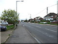
1
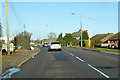
Jaywick Lane
Heading north away from Jaywick.
Image: © Robin Webster
Taken: 30 Nov 2018
0.12 miles
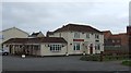
5
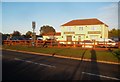
Clacton-on-Sea: Wick Lodge
Wick Lodge is a pub and restaurant on Jaywick Lane.
Old large scale Ordnance Survey maps show that it is on the site of an old farmstead called Summerhouse Farm that existed from at least 1874 to at least 1923. However by the time that the 1939 edition of the mapping was published it was being shown as Wick Lodge.
Image: © Nigel Cox
Taken: 28 Oct 2018
0.15 miles
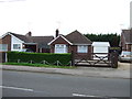
6
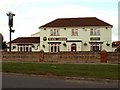
'Wick Lodge' public house, Jaywick, Essex
Image: © Robert Edwards
Taken: 4 Oct 2006
0.17 miles