IMAGES TAKEN NEAR TO
Barrington Gardens, CLACTON-ON-SEA, CO15 5BB
Introduction
This page details the photographs taken nearby to Barrington Gardens, CO15 5BB by members of the Geograph project.
The Geograph project started in 2005 with the aim of publishing, organising and preserving representative images for every square kilometre of Great Britain, Ireland and the Isle of Man.

There are currently over 7.5m images from over14,400 individuals and you can help contribute to the project by visiting https://www.geograph.org.uk
Image Map (Loading...)


Getting Data...Please wait
Leaflet Map data © OpenStreetMap
Images are licensed for reuse under creativecommons.org/licenses/by-sa/2.0
Notes
- Clicking on the map will re-center to the selected point.
- The higher the marker number, the further away the image location is from the centre of the postcode.
Image Listing (6 Images Found)
Images are licensed for reuse under creativecommons.org/licenses/by-sa/2.0
Image
Details
Distance
3
Road junction at Great Clacton, Essex
This is where the B.1032 meets the B.1027
Image: © Robert Edwards
Taken: 4 Oct 2006
0.20 miles
5
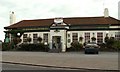
'The Roaring Donkey' public house
This pub stands along the B.1032
Image: © Robert Edwards
Taken: 4 Oct 2006
0.24 miles
6
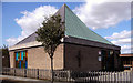
Methodist Church, Holland-on-Sea, Essex
Image: © Peter Stack
Taken: 29 Aug 2009
0.25 miles