IMAGES TAKEN NEAR TO
Clements Green Lane, CHELMSFORD, CM3 5LB
Introduction
This page details the photographs taken nearby to Clements Green Lane, CM3 5LB by members of the Geograph project.
The Geograph project started in 2005 with the aim of publishing, organising and preserving representative images for every square kilometre of Great Britain, Ireland and the Isle of Man.

There are currently over 7.5m images from over14,400 individuals and you can help contribute to the project by visiting https://www.geograph.org.uk
Image Map (Loading...)


Getting Data...Please wait
Leaflet Map data © OpenStreetMap
Images are licensed for reuse under creativecommons.org/licenses/by-sa/2.0
Notes
- Clicking on the map will re-center to the selected point.
- The higher the marker number, the further away the image location is from the centre of the postcode.
Image Listing (3 Images Found)
Images are licensed for reuse under creativecommons.org/licenses/by-sa/2.0
Image
Details
Distance
1
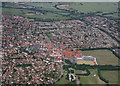
South Woodham Ferrers
The Compass Gardens can be seen in the bottom right of the picture.
Image: © terry joyce
Taken: 28 Jun 2010
0.03 miles
2
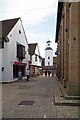
Towards QEII Square
The clock tower is in the Queen Elizabeth Square opened by the Queen in 1981
Image: © Glyn Baker
Taken: 30 Aug 2013
0.20 miles
3
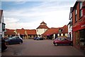
Chandlers Walk
Looking towards the Town Crier pub
Image: © Glyn Baker
Taken: 30 Aug 2013
0.21 miles