IMAGES TAKEN NEAR TO
Hamlet Hill, HARLOW, CM19 5LA
Introduction
This page details the photographs taken nearby to Hamlet Hill, CM19 5LA by members of the Geograph project.
The Geograph project started in 2005 with the aim of publishing, organising and preserving representative images for every square kilometre of Great Britain, Ireland and the Isle of Man.

There are currently over 7.5m images from over14,400 individuals and you can help contribute to the project by visiting https://www.geograph.org.uk
Image Map (Loading...)


Getting Data...Please wait
Leaflet Map data © OpenStreetMap
Images are licensed for reuse under creativecommons.org/licenses/by-sa/2.0
Notes
- Clicking on the map will re-center to the selected point.
- The higher the marker number, the further away the image location is from the centre of the postcode.
Image Listing (5 Images Found)
Images are licensed for reuse under creativecommons.org/licenses/by-sa/2.0
Image
Details
Distance
1
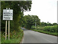
Entering Roydon Hamlet from the west
The road is called Hamlet Hill.
Image: © Robin Webster
Taken: 17 Aug 2015
0.10 miles
2
View north from Nazeing churchyard
Towards Roydon Hamlet.
Image: © Robin Webster
Taken: 13 Mar 2014
0.17 miles
3
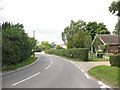
Roydon Hamlet
Three roads meet in the centre of this hamlet. This one - Hamlet Hill - has bungalows either side. Perhaps planning policy forbids two-storey developments here on top of the hill?
Image: © Stephen Craven
Taken: 15 Aug 2009
0.19 miles
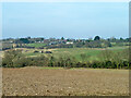
4
Field of stubble near Roydon Hamlet
A large field with only the stubble left after harvesting. In the distance are some of the many commercial nurseries around Nazeing.
Image: © Stephen Craven
Taken: 15 Aug 2009
0.20 miles
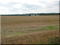
5
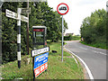
Phone box and signage, Roydon Hamlet
A modern style phone box stands at the junction of Hamlet Hill (signed here towards Nazeing), Reeves Lane (towards Roydon) and Tylers Road (towards Epping).
Image: © Stephen Craven
Taken: 15 Aug 2009
0.23 miles