IMAGES TAKEN NEAR TO
Dale Avenue, WIRRAL, CH62 7DZ
Introduction
This page details the photographs taken nearby to Dale Avenue, CH62 7DZ by members of the Geograph project.
The Geograph project started in 2005 with the aim of publishing, organising and preserving representative images for every square kilometre of Great Britain, Ireland and the Isle of Man.

There are currently over 7.5m images from over14,400 individuals and you can help contribute to the project by visiting https://www.geograph.org.uk
Image Map (Loading...)


Getting Data...Please wait
Leaflet Map data © OpenStreetMap
Images are licensed for reuse under creativecommons.org/licenses/by-sa/2.0
Notes
- Clicking on the map will re-center to the selected point.
- The higher the marker number, the further away the image location is from the centre of the postcode.
Image Listing (7 Images Found)
Images are licensed for reuse under creativecommons.org/licenses/by-sa/2.0
Image
Details
Distance
1
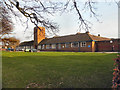
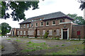
Wirral Professional Excellence Centre
This former school, on Acre Lane, is now "The Wirral Professional Excellence Centre".
Image: © David Dixon
Taken: 3 Mar 2011
0.15 miles
2
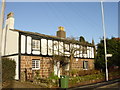
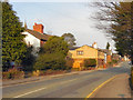
Spring Cottage, Bromborough
Spring Cottage, Rake Lane, Bromborough.
Image: © Sue Adair
Taken: 11 Jan 2006
0.18 miles
3
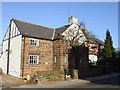
Pear Tree Cottage, Rake Lane, Bromborough
Image: © Sue Adair
Taken: 11 Jan 2006
0.18 miles
4
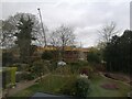
New housing estate in Bromborough
The site of this housing estate used to be a school field. This is the view of the construction from Brancote Gardens
Image: © Philip Lloyd
Taken: 7 Apr 2021
0.23 miles
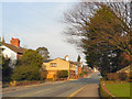
7
Former pub, Bromborough
The Archers, a spacious estate pub, died in its mid-50s in around 2013.
All trace has since been obliterated and flats built on the site.
Image: © Stephen Richards
Taken: 21 Aug 2014
0.24 miles