IMAGES TAKEN NEAR TO
Greenacres Close, PRENTON, CH43 7ZF
Introduction
This page details the photographs taken nearby to Greenacres Close, CH43 7ZF by members of the Geograph project.
The Geograph project started in 2005 with the aim of publishing, organising and preserving representative images for every square kilometre of Great Britain, Ireland and the Isle of Man.

There are currently over 7.5m images from over14,400 individuals and you can help contribute to the project by visiting https://www.geograph.org.uk
Image Map (Loading...)


Getting Data...Please wait
Leaflet Map data © OpenStreetMap
Images are licensed for reuse under creativecommons.org/licenses/by-sa/2.0
Notes
- Clicking on the map will re-center to the selected point.
- The higher the marker number, the further away the image location is from the centre of the postcode.
Image Listing (15 Images Found)
Images are licensed for reuse under creativecommons.org/licenses/by-sa/2.0
Image
Details
Distance
1
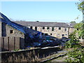
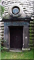
Bidston Hall Farm
Facing Bidston Hall is Bidston Hall Farm, the buildings are now in the process of being converted into residential accommodation.
Image: © Sue Adair
Taken: 13 Nov 2005
0.18 miles
2
Bidston Observatory
Long associated with weather and tidal research, the observatory was relocated from Liverpool's Waterloo Dock in 1866. Bidston Observatory is faced with sandstone excavated from the site. There was an equatorial telescope in the west dome, which was used mainly for the observation of comets, and a transit telescope in the east dome, which was regularly used for the determination of time from the stars. These telescopes are now in Liverpool Museum.
Image: © Sue Adair
Taken: 13 Nov 2005
0.19 miles
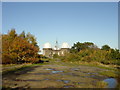
3

Bidston Observatory & Lighthouse in the distance
The original Bidston Observatory & Bidston Lighthouse can be seen above the treeline of Bidston Hill. The picture is taken from Upton Park, the M53 Moreton Spur motorway junction is in between.
Image: © El Pollock
Taken: 15 Jul 2009
0.20 miles
5

Bidston Hall
Bidston Hall is an early seventeenth century house associated with William Stanley, sixth Earl of Derby, who died 1627. It was more recently occupied by Sir Robert Vyner who gave the land on Bidston Hill for the observatory. It is built of yellow sandstone, the front approach is through a square court, with a handsome gateway having a singular arch highly ornamented with the cognizances of the Derby family. In some intermediatory purchase it is said Bidston Hall was won and lost at cards, to commemorate which a summer-house was built in the form of a club, the foundations of which still remain in the picturesque grounds attached to the hall.
Image: © Sue Adair
Taken: 13 Nov 2005
0.21 miles

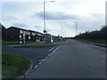
7
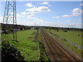
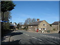
All Heading South.
The road, electricity pylons and the railway line all heading south. Junction 2 of the M53 is just visible on the right-hand side. Taken from the bridge.
Image: © David Quinn
Taken: 4 Sep 2007
0.23 miles
9
Stone Farm, Fender Lane, Bidston
Stone farm, formerly the Ring o' Bells Inn at the junction of School Lane with Fender Lane. The last landlord, Simon Croft, also one of the inn's best customers, did little to discourage drunken behaviour, which distressed the churchgoers and led to the inn being closed down in 1868 leaving the village with no licensed premises.
Image: © Sue Adair
Taken: 4 Apr 2007
0.23 miles
10
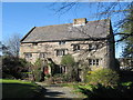
Church Farm, Bidston
This unusual looking farmhouse is medieval, it is situated opposite St Oswald's Church in Bidston Village. Once thought to have been a monastic building, it was built on thirteen different levels with thirteen flights of stairs, no two rooms being built on the same level, as can be seen by the position of the windows.
Image: © Sue Adair
Taken: 4 Apr 2007
0.23 miles