1
A4233 heads east away from Cymmer, Porth
Destinations shown on the sign on the left are Aberdare, Pontypridd and Porth town centre.
Image: © Jaggery
Taken: 30 Jul 2014
0.07 miles
2
Glynfach Road, Cymmer, Porth
Viewed from the edge of The Rhondda. http://www.geograph.org.uk/photo/4096532
Image: © Jaggery
Taken: 30 Jul 2014
0.07 miles
3
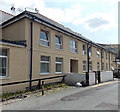
St. John's Street, Cymmer
A particularly bright row of terraced housing. They also look a bit bigger than usual and by their location up the hillside may be 1930s and have belonged to the first line supervisory staff.
Image: © Graham Horn
Taken: 4 Oct 2008
0.07 miles
4
A4233 at Porth
Image: © Colin Pyle
Taken: 9 Sep 2011
0.07 miles
5
Turning for Pontypridd
Image: © Roger Cornfoot
Taken: 3 Apr 2017
0.10 miles
6
Tai Cwm, Office Street, Cymmer, Porth
Flats near Cymmer Colliery Workingmen's Institute. http://www.geograph.org.uk/photo/4096430
Image: © Jaggery
Taken: 30 Jul 2014
0.10 miles
7
Houses on the north side of School Street, Cymmer, Porth
Looking east from High Street.
Image: © Jaggery
Taken: 30 Jul 2014
0.11 miles
8
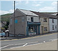
The Cwtch, High Street, Cymmer, Porth
The Cwtch provides a repair & alterations service, and sells soft furnishings and "shabby chic" gifts. Mr Frank Cottle, who was born in Cymmer, remembers that the shop was Lloyds the butchers when he left the area in 1956.
Image: © Jaggery
Taken: 30 Jul 2014
0.11 miles
9
Spar, Cymmer, Porth
The Spar shop is at 36 High Street, Cymmer, Porth.
The name on the shuttered shop on the right is CAPITAL VIDEO.
Image: © Jaggery
Taken: 30 Jul 2014
0.11 miles
10
Ordnance Survey Cut Mark
This OS cut mark can be found on the east face of No1 Cross Street. It marks a point 117.238m above mean sea level.
Image: © Adrian Dust
Taken: 4 Jun 2017
0.11 miles


