1
Groes Fawr Close, Marshfield
Houses built in the second decade of the 21st century viewed
across Church Lane near the Marshfield Road junction in March 2019.
Image: © Jaggery
Taken: 21 Mar 2019
0.01 miles
2
Surface water on Church Lane, Marshfield
Large puddle across Church Lane viewed on March 21st 2019.
Image: © Jaggery
Taken: 21 Mar 2019
0.02 miles
3
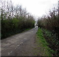
Church Lane towards Marshfield Road, Marshfield
Looking to the SSW from allotment entrance gates. https://www.geograph.org.uk/photo/6146961
A drainage channel is on the right.
Image: © Jaggery
Taken: 21 Mar 2019
0.02 miles
4
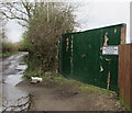
Groes Farm entrance gates, Church Lane, Marshfield
Located here. https://www.geograph.org.uk/photo/6146928 The notice states
Please Do Not Obstruct These Gates - Farm Entrance in Use 24 hrs.
Image: © Jaggery
Taken: 21 Mar 2019
0.03 miles
5
BT phonebox alongside a Marshfield Road bus stop, Marshfield
Telephone equipment remains in the phonebox in March 2019 at a time when many public phoneboxes in the UK have been removed - or had their phone equipment removed. Most people in the UK now own a mobile phone, though acquiring a mobile signal is patchy or not possible in some rural areas.
Image: © Jaggery
Taken: 21 Mar 2019
0.03 miles
6
Marshfield : Church Lane
Looking along Church Lane.
Image: © Lewis Clarke
Taken: 14 Nov 2018
0.03 miles
7
Blacktown electricity substation, Church Lane, Marshfield
Western Power Distribution electricity substation in a brick enclosure near the Marshfield Road junction.
The substation identifier is BLACKTOWN S/S 512103
Image: © Jaggery
Taken: 21 Mar 2019
0.03 miles
8
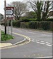
Direction signs on a Marshfield corner
Left along Church Lane for St Mary's Church.
Right along St Mellons Road for Gateway Christian Centre.
Ahead along Marshfield Road for Y Maerun pub & dining.
Image: © Jaggery
Taken: 21 Mar 2019
0.04 miles
9
Bench on a green in the centre of Marshfield
Near the crossroads of Marshfield Road, St Mellons Road and Church Lane.
Image: © Jaggery
Taken: 21 Mar 2019
0.04 miles
10
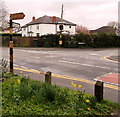
Old signpost at crossroads in the centre of Marshfield
Right along Marshfield Road for Castleton and Newport.
Along St Mellons Road for the village hall.
Image: © Jaggery
Taken: 21 Mar 2019
0.04 miles


