1
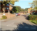
Cardiff : Eastern Avenue heading west
Viewed from Ty Gwyn Road bridge. Eastern Avenue (A48) heads in the direction of the Gabalfa Interchange, about 3 kilometres away.
Image: © Jaggery
Taken: 11 Oct 2010
0.11 miles
2
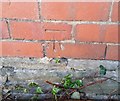
Cut Benchmark - Birchwood Road
A cut benchmark on the gatepost of the college entrance on Birchwood Road
Image: © Father Ted
Taken: 2 Jul 2020
0.13 miles
3
Glenside Court, Cardiff
Built in 1989, Glenside Court contains 52 flats. It is located on the eastern side of Ty Gwyn Road, just north of the bridge over Eastern Avenue (A48). There is a resident management staff and community alarm service. New residents must be at least 60 years old. Glenside Court consists of five buildings named Dyfed House, Powys House, Gwent House, Clwyd House and Gwynedd House.
Image: © Jaggery
Taken: 11 Oct 2010
0.14 miles
4
A48 at Bronwydd Avenue overbridge
Image: © Colin Pyle
Taken: 3 Jan 2020
0.16 miles
5
University Hall, Penylan, Cardiff
Viewed from Ty Gwyn Road. The multi-storey university hall is located on Birchwood Lane. It has accommodation for 673 students, either in standard rooms with shared bathroom facilities, or 251 more expensive rooms with en-suite facilities.
Image: © Jaggery
Taken: 11 Oct 2010
0.16 miles
6
Cardiff : Ty Gwyn Road crosses above Eastern Avenue
The view south along the bridge carrying Ty Gwyn Road above Eastern Avenue (A48).
Image: © Jaggery
Taken: 11 Oct 2010
0.17 miles
7
Ordnance Survey Cut Mark
This OS cut mark can be found on No45 Ty Draw Road. It marks a point 15.499m above mean sea level.
Image: © Adrian Dust
Taken: 19 Nov 2017
0.18 miles
8
Ordnance Survey Cut Mark
This OS cut mark can be found on No56 Ty Draw Road. It marks a point 15.627m above mean sea level.
Image: © Adrian Dust
Taken: 19 Nov 2017
0.19 miles
9
Ordnance Survey Cut Mark
This OS cut mark can be found on No28 Ty Draw Road. It marks a point 15.466m above mean sea level.
Image: © Adrian Dust
Taken: 19 Nov 2017
0.20 miles
10
Entrance to St David's College, Cardiff
The entrance to St David's Catholic Sixth Form College is from Ty Gwyn Road, about 100 metres south of the bridge http://www.geograph.org.uk/photo/2116017 over Eastern Avenue (A48).
Image: © Jaggery
Taken: 11 Oct 2010
0.22 miles


