1
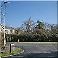
South Road Play Area
Er, that's it. Oh and there's a goalpost to the left.
Image: © Keith Edkins
Taken: 16 Jan 2008
0.07 miles
2
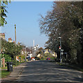
The corner of Mill Road and Impington windmill
The windmill is Grade II* listed.
Image: © John Sutton
Taken: 22 Mar 2016
0.10 miles
3
Fitting the sails, Impington Windmill - 4
Making adjustments to the lifting gear before starting to lift the second sail. Further pictures of the operation follow in series here: http://www.geograph.org.uk/search.php?i=5090979
Image: © Gareth Hughes
Taken: 9 Sep 2007
0.14 miles
4
Fitting the sails, Impington Windmill - 6
The second sail nearly in position for fixing - which required some circus-style acrobatics from the team fitting the sails. Further pictures of the operation follow in series here: http://www.geograph.org.uk/search.php?i=5090979
Image: © Gareth Hughes
Taken: 9 Sep 2007
0.14 miles
5
On Cambridge Road in early spring
Grade II* listed Impington Mill shows above the rooftops.
Image: © John Sutton
Taken: 22 Mar 2016
0.14 miles
6
Fitting the sails, Impington Windmill - 3
Starting to lift the second sail using a Tirfor winch, and block and tackle for the safety rope. Further pictures of the operation follow in series here: http://www.geograph.org.uk/search.php?i=5090979
Image: © Gareth Hughes
Taken: 9 Sep 2007
0.14 miles
7
Fitting the sails, Impington Windmill - 7
One of the team up a ladder positioning the bolts which fix the sail to the stock. At this point, the sail itself is held up only by the ropes and cables. Further pictures of the operation follow in series here: http://www.geograph.org.uk/search.php?i=5090979
Image: © Gareth Hughes
Taken: 9 Sep 2007
0.15 miles
8
Fitting the sails, Impington Windmill - 5
The second sail halfway up the mill. Most of the village had turned out to watch. Further pictures of the operation follow in series here: http://www.geograph.org.uk/search.php?i=5090979
Image: © Gareth Hughes
Taken: 9 Sep 2007
0.15 miles
9
Fitting the sails, Impington Windmill - 2
A closer view, showing the second sail on its dolly waiting to be hauled into position. Because of the narrow access, the work was done by traditional methods, rather than using a crane. Further pictures of the operation follow in series here: http://www.geograph.org.uk/search.php?i=5090979
Image: © Gareth Hughes
Taken: 9 Sep 2007
0.15 miles
10
Renovating Impington Mill
Image: © Kim Fyson
Taken: 29 Aug 2005
0.15 miles


