IMAGES TAKEN NEAR TO
Devonshire Road, CAMBRIDGE, CB1 2AG
Introduction
This page details the photographs taken nearby to Devonshire Road, CB1 2AG by members of the Geograph project.
The Geograph project started in 2005 with the aim of publishing, organising and preserving representative images for every square kilometre of Great Britain, Ireland and the Isle of Man.

There are currently over 7.5m images from over14,400 individuals and you can help contribute to the project by visiting https://www.geograph.org.uk
Image Map (Loading...)


Getting Data...Please wait
Leaflet Map data © OpenStreetMap
Images are licensed for reuse under creativecommons.org/licenses/by-sa/2.0
Notes
- Clicking on the map will re-center to the selected point.
- The higher the marker number, the further away the image location is from the centre of the postcode.
Image Listing (1505 Images Found)
Images are licensed for reuse under creativecommons.org/licenses/by-sa/2.0
Image
Details
Distance
10
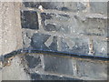
Benchmark at 20 Devonshire Road, Cambridge
This benchmark is located on the SE face of No. 20 Devonshire Road in Cambridge and it is shown in the current Ordnance Survey database at a height of 16.1087m above the Newlyn datum.
Image: © Meirion
Taken: 28 May 2012
0.02 miles