1
Adding to the timetables
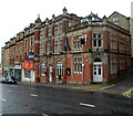
The church at the top of Whiteladies Road was founded around 1850 as the United Methodist church; it changed in 1932 into the Mount of Olives Assembly (Pentecostal) but eventually closed in 1979. The building now serves the local community as a gymnasium, with recent banners offering martial arts classes now.
Image: © Neil Owen
Taken: 7 Sep 2017
0.01 miles
2
Demolition of filling station on Blackboy Hill
During transformation from an Esso to an Asda outlet. By a curious coincidence, I patronised this very filling station today a few hours before submitting this, nearly five months after taking the photo, though I snobbishly try to avoid supermarket chains with four-letter names.
Image: © Derek Harper
Taken: 25 Jun 2015
0.01 miles
3
Demolition of filling station on Blackboy Hill
Another view of
Image], with the rather sinister pulveriser at work on the old canopy.
Image: © Derek Harper
Taken: 25 Jun 2015
0.01 miles
4
Ordnance Survey Cut Mark
This OS cut mark can be found on the Pentecostal Chapel on Whiteladies Road. It marks a point 88.398m above mean sea level.
Image: © Adrian Dust
Taken: 1 Mar 2016
0.02 miles
5
Blackboy Hill
Taken next to the clock tower at the top of this busy road.
Image: © Colin Bews
Taken: 4 Sep 2011
0.02 miles
6
Estate agents, Whiteladies Road, Bristol
Andrews are on the corner of Highland Crescent - actually, there seem to be two corners.
Image: © Derek Harper
Taken: 25 Jun 2015
0.02 miles
7
The Kings Arms, Clifton, Bristol
The pub at 168 Whiteladies Road, on the corner of York Street, was formerly named The Black Bear.
Image: © Jaggery
Taken: 7 May 2012
0.02 miles
8
Bristol : Redland - Whiteladies Road A4018
Looking along Whiteladies Road on a wet afternoon.
Image: © Lewis Clarke
Taken: 11 Jul 2023
0.03 miles
9
Getting older with a new sign
The Port of Call has a new version of its pub sign - and appears to have pushed back its age compared to the previous! See
Image
Image: © Neil Owen
Taken: 7 Sep 2017
0.03 miles
10
Blackboy Hill - BS8
This is Yorke Street, a short, steep hump-backed road with not much to say for itself except that it might be deemed a fair representation of the local streets that have a village feel about them despite existing in a busy suburb. The bay-windowed property at the brow of the hill is The Port of Call pub.
Image: © David Hallam-Jones
Taken: 31 Jul 2012
0.03 miles


