1
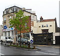
The Black Boy Inn, Lower Redland Road, Bristol
A famous old Bristol hostelry.
Image: © Jeremy Bolwell
Taken: 9 May 2015
0.02 miles
2
The latest incarnation
The Black Boy Inn has a new sign and a lick of paint. Again.
Image: © Neil Owen
Taken: 7 Sep 2017
0.02 miles
3
Signs of a Past Life
The side of this building obviously used to be used to display advertisements mostly relating to cycling and also I can make out an Ironmonger.
Image: © Linda Bailey
Taken: 20 Nov 2006
0.03 miles
4
Woodbury Lane, Bristol
A little cul-de-sac bends to meet Whiteladies Road.
Image: © Derek Harper
Taken: 5 Jun 2017
0.03 miles
5
A puzzling park
Ground floor parking in Highland Square features an unusual design. It's been here for over a decade but no-one's finished it yet.
Image: © Neil Owen
Taken: 22 Mar 2022
0.03 miles
6
Whiteladies Road, Northern End, BS8
This is The Black Boy pub on the corner plot where Lower Redland Road joins and/or leaves Whiteladies Road. The myth that this pub was associated with the presence of a substantial number of young African slaves in this area, albeit Bristol's appalling record in slave trading, has by now almost been laid to rest. It seems that in the early 18th century there was an inn hereabouts that stood on an island of land in the middle of this main thoroughfare, a hostelry called The Blackamoor's Head Inn. However, by 1803 it had become known as The Blackboy Tavern. It seems that these premises were demolished in 1874 to allow for changes to the road, since up until this time the pub had straddled the road, thereby forcing traffic to pass round it. But how the inn got its original name and its subsequent names appears to remain the subject of debate.
Image: © David Hallam-Jones
Taken: 31 Jul 2012
0.03 miles
7
Wellington Park, Bristol
With the junction with Whiteladies Road; on the far side is the Black Boy Inn https://www.historicengland.org.uk/listing/the-list/list-entry/1220168 ; see also http://www.geograph.org.uk/search.php?i=64607701 .
Image: © Derek Harper
Taken: 18 Apr 2016
0.03 miles
8
The Black Boy Inn, Bristol
18th century pub at 171 Whiteladies Road, on the corner of Lower Redland Road.
Here's http://www.geograph.org.uk/photo/2384 a view taken a decade earlier.
Image: © Jaggery
Taken: 7 May 2012
0.03 miles
9
Tesco Express and post office, Whiteladies Road, Bristol
The post office is inside Tesco Express at 169 Whiteladies Road, on the corner of Lower Redland Road. The presence of a double postbox on the right suggests that the premises may have been a post office in its own right before Tesco acquired the site.
Image: © Jaggery
Taken: 7 May 2012
0.03 miles
10
Jersey Lily, Bristol
Pub at 193 Whiteladies Road, on the corner of Woodbury Lane. Though the current pub sign shows a white lily, a previous pub sign here depicted Lily Langtry (1853-1929), Jersey-born music hall singer, stage actress and a mistress of the Prince of Wales (later King Edward VII).
Image: © Jaggery
Taken: 7 May 2012
0.03 miles


