1
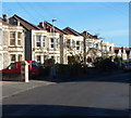
Hampden Road, Knowle, Bristol
Houses on the north side of Hampden Road viewed from Harrowdene Road.
Image: © Jaggery
Taken: 11 Nov 2012
0.04 miles
2
Houses at the eastern end of Beaconsfield Road, Knowle, Bristol
Viewed from the corner of Maxse Road looking towards Harrowdene Road.
Image: © Jaggery
Taken: 11 Nov 2012
0.04 miles
3
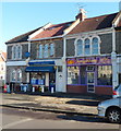
Xing Wang, Knowle, Bristol
Chinese takeaway at 17 Harrowdene Road.
Its neighbour on the left is Star Value, convenience store and off licence.
Image: © Jaggery
Taken: 11 Nov 2012
0.04 miles
4
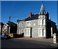
23 and 25 Beaconsfield Road, Knowle, Bristol
Viewed from the corner of Maxse Road. These two semi-detached houses are bigger than, and distinctly different from, neighbouring houses. A stone inscription on the wall shows the year 1902.
Image: © Jaggery
Taken: 11 Nov 2012
0.07 miles
5
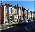
Harrowdene Road houses, Knowle, Bristol
Viewed from near the corner of Beaconsfield Road.
Image: © Jaggery
Taken: 11 Nov 2012
0.07 miles
6
Cleeve Road, Knowle, Bristol
Viewed from Harrowdene Road.
Image: © Jaggery
Taken: 11 Nov 2012
0.12 miles
7
Maxse Road, Knowle, Bristol
A view NW from Greenmore Road.
According to one online source, this is the only Maxse Road in the UK.
Image: © Jaggery
Taken: 11 Nov 2012
0.13 miles
8
Carriage turning
The elegant, open and stylish plan of Arnos Vale includes this carriage turning at the southern heights.
Image: © Neil Owen
Taken: 24 Jan 2017
0.13 miles
9
Arno's Court Park
The top of the park, with a steep slope below a pair of semis on Cleeve Road.
Image: © Derek Harper
Taken: 17 Nov 2013
0.14 miles
10
Cleve House School, Knowle, Bristol
The school is at 254 Wells Road, opposite Woodbridge Road.
The school has been on this site since 1948. Originally named Arcadia, Cleve House on the right was built in 1887 by Charles Beavis, a Victorian entrepreneur. It became known locally as the Lemonade Palace, because C.E.Beavis manufactured soft drinks in Jacob Street in the old market area of Bristol.
Image: © Jaggery
Taken: 11 Nov 2012
0.14 miles


