IMAGES TAKEN NEAR TO
Harcombe Road, BRISTOL, BS36 1JA
Introduction
This page details the photographs taken nearby to Harcombe Road, BS36 1JA by members of the Geograph project.
The Geograph project started in 2005 with the aim of publishing, organising and preserving representative images for every square kilometre of Great Britain, Ireland and the Isle of Man.

There are currently over 7.5m images from over14,400 individuals and you can help contribute to the project by visiting https://www.geograph.org.uk
Image Map (Loading...)


Getting Data...Please wait
Leaflet Map data © OpenStreetMap
Images are licensed for reuse under creativecommons.org/licenses/by-sa/2.0
Notes
- Clicking on the map will re-center to the selected point.
- The higher the marker number, the further away the image location is from the centre of the postcode.
Image Listing (5 Images Found)
Images are licensed for reuse under creativecommons.org/licenses/by-sa/2.0
Image
Details
Distance
1
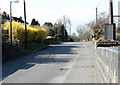
2011 : Dragon Road from the railway bridge
Forsythia reigns supreme.
Image: © Maurice Pullin
Taken: 20 Mar 2011
0.07 miles
3
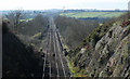
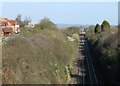
2011 : Railway from the overbridge on Dragon Road
Looking east along the line built by the GWR to make a more direct route between Paddington and South Wales via the Severn Tunnel. Avoids the loop south via Bath and Bristol, joining the main line south of Wootton Bassett.
Image: © Maurice Pullin
Taken: 20 Mar 2011
0.22 miles
4
2011 : Railway to South Wales from Paddington
Looking west along the line built by the GWR to make a more direct route between Paddington and South Wales. Leaving the main line south of Wootton Bassett it avoids the loop south via Bath and Bristol. The line from Wootton Bassett is cuttings, embankments and tunnels all the way making it very expensive to build. Then there is the Severn Tunnel!
Image: © Maurice Pullin
Taken: 20 Mar 2011
0.24 miles