IMAGES TAKEN NEAR TO
Mill Lane, WEDMORE, BS28 4DW
Introduction
This page details the photographs taken nearby to Mill Lane, BS28 4DW by members of the Geograph project.
The Geograph project started in 2005 with the aim of publishing, organising and preserving representative images for every square kilometre of Great Britain, Ireland and the Isle of Man.

There are currently over 7.5m images from over14,400 individuals and you can help contribute to the project by visiting https://www.geograph.org.uk
Image Map (Loading...)


Getting Data...Please wait
Leaflet Map data © OpenStreetMap
Images are licensed for reuse under creativecommons.org/licenses/by-sa/2.0
Notes
- Clicking on the map will re-center to the selected point.
- The higher the marker number, the further away the image location is from the centre of the postcode.
Image Listing (4 Images Found)
Images are licensed for reuse under creativecommons.org/licenses/by-sa/2.0
Image
Details
Distance
2
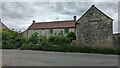
Latcham House Farmhouse
https://historicengland.org.uk/listing/the-list/list-entry/1252917?section=official-list-entry
Image: © Sandy Gerrard
Taken: 30 May 2024
0.19 miles
3
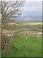
View NE from Latcham
Another view over the Levels to the Mendips in the distance
Image: © Graham Richards
Taken: 27 Dec 2005
0.20 miles
4
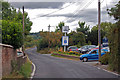
B3139 passes a Garage
Approaching Wedmore.
Image: © J.Hannan-Briggs
Taken: 31 Jul 2014
0.24 miles