IMAGES TAKEN NEAR TO
Watch House Road, BRISTOL, BS20 0EP
Introduction
This page details the photographs taken nearby to Watch House Road, BS20 0EP by members of the Geograph project.
The Geograph project started in 2005 with the aim of publishing, organising and preserving representative images for every square kilometre of Great Britain, Ireland and the Isle of Man.

There are currently over 7.5m images from over14,400 individuals and you can help contribute to the project by visiting https://www.geograph.org.uk
Image Map (Loading...)


Getting Data...Please wait
Leaflet Map data © OpenStreetMap
Images are licensed for reuse under creativecommons.org/licenses/by-sa/2.0
Notes
- Clicking on the map will re-center to the selected point.
- The higher the marker number, the further away the image location is from the centre of the postcode.
Image Listing (125 Images Found)
Images are licensed for reuse under creativecommons.org/licenses/by-sa/2.0
Image
Details
Distance
1
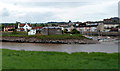
Across the River Avon from Bristol to North Somerset
A view from the edge of Shirehampton, Bristol to riverside buildings in Pill, North Somerset.
The tidal inlet on the right is Crockerne Pill, which was the original name of the village.
Image: © Jaggery
Taken: 23 Jun 2012
0.02 miles
4
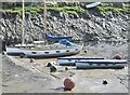
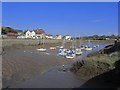
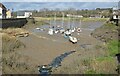
Boats and Buoys
Pill Harbour at low tide
Image: © Anthony O'Neil
Taken: 25 Feb 2021
0.03 miles
5
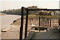
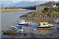
Mucking about at Pill
Somerset (North that is), Pill, one of the many, Yeo Pill for example, but this is The Pill on the River Avon, one time Ferry to Shirehampton and long overdue for at least a footbridge; The Somerset Avon that is, not Warkwickshire, nor the Dorset Avon (Hampshire Avon, Salisbury Avon). The mud flowing down from Bristol, Westbury Trym Brook, Bath and the Cotswold is shown in the background. The intention was to try to replace the long missed Pill Ferry with a Rail and footbridge (on the level) and stop pretending Bristol is a major sea port, seize up the Cumberland Basin Bridge !!!, or put in a new road network, communicate.
Image: © Michael Dennis Stagg
Taken: 19 Apr 2010
0.03 miles

7
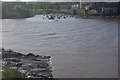
River Avon, Shirehampton
The tidal Avon laps at its muddy banks where, until 1973, a ferry operated across to Pill which can be seen on the opposite bank.
Image: © Stephen McKay
Taken: 10 Nov 2010
0.04 miles
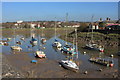
9
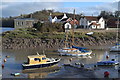
Pill Harbour at low tide
The Avon can have a seven metre rise and fall here. In the 19th century, vessels not wishing to risk the hazardous voyage up river to Bristol moored off Pill and discharged their cargo into small boats for transportation to the port. This provided the village of Pill with a constant demand for marine services and manpower.
Image: © Anthony O'Neil
Taken: 25 Feb 2021
0.04 miles