IMAGES TAKEN NEAR TO
Water Lane, BRISTOL, BS1 6WG
Introduction
This page details the photographs taken nearby to Water Lane, BS1 6WG by members of the Geograph project.
The Geograph project started in 2005 with the aim of publishing, organising and preserving representative images for every square kilometre of Great Britain, Ireland and the Isle of Man.

There are currently over 7.5m images from over14,400 individuals and you can help contribute to the project by visiting https://www.geograph.org.uk
Image Map (Loading...)


Getting Data...Please wait
Leaflet Map data © OpenStreetMap
Images are licensed for reuse under creativecommons.org/licenses/by-sa/2.0
Notes
- Clicking on the map will re-center to the selected point.
- The higher the marker number, the further away the image location is from the centre of the postcode.
Image Listing (1111 Images Found)
Images are licensed for reuse under creativecommons.org/licenses/by-sa/2.0
Image
Details
Distance
1
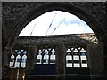
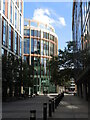
Centuries of building in Bristol
Looking from the inside of the ruined Temple Church, there are modern office blocks and yet more to be opened beyond.
Image: © Neil Owen
Taken: 10 Sep 2021
0.01 miles
2
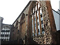
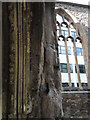
Temple shades
The church was built largely in the thirteenth and fourteenth centuries, with some parts dating back as early as the twelfth. However, the fire caused by the Blitz generated such a temperature that the stone and plasterwork changed colour. There is a pinkish tinge to the parts exposed to the flames, as well as structural changes that are making them weaker.
Image: © Neil Owen
Taken: 10 Sep 2021
0.01 miles
3
A kiln of God's house
The fire caused by incendiaries in WWII did great damage to the interior of Temple Church. The stone and plasterwork were subjected to such an inferno that the stone changed colour and is now a distinctly pinkish hue.
Image: © Neil Owen
Taken: 10 Sep 2021
0.01 miles
4
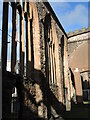
The heat of the fire
Looking from the outside of Temple Church, the ruins tell a story of a terrible fire. Hit by incendiaries in WWII, the interior was gutted in a fierce blaze; the heat generated caused the stonework to change colour. Looking at the empty window surround, the pinkish hue is clear to see as it faces inwards.
Image: © Neil Owen
Taken: 10 Sep 2021
0.01 miles
5
A new building at the end of Temple Street
'Halo' is just about finished now.
Image: © Neil Owen
Taken: 13 Sep 2023
0.01 miles
6
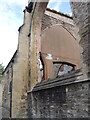
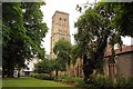
A terrible inferno
Temple Church suffered a terrible fire - as did many other buildings nearby, including churches - after an air-raid in November, 1940. Here the stress of the raging fire and the weight of the falling roof are clear to see.
Image: © Neil Owen
Taken: 10 Sep 2021
0.02 miles
7
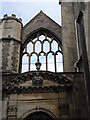
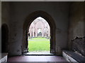
Porch of Temple Church
The west entrance of the church, with the wall and window behind. The porch and wall dates from the fourteenth century, with post-Mediaeval additions to the porch.
Image: © Neil Owen
Taken: 10 Sep 2021
0.02 miles
9
Temple Church
Blitzed during the war, the church was not demolished - it was one of the largest and most important churches in Bristol partly due to the wealth of the weavers in this area. Temple was where cloth workers lived and worked in the medieval period.
Image: © Eirian Evans
Taken: 20 Feb 2018
0.02 miles
10
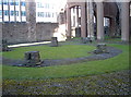
A round church in a rectangular church
Temple or Holy Cross church is an ancient place of worship that was gutted in the Blitz. However, the destruction of the flooring allowed archaeological excavations to reveal what appears to be an earlier church - a round one. It dates back to about the 1130s and was founded by the Order of the Knights Templar. The area of Temple receives its name thus.
Outlining the foundations are a couple of cobbled rings set into the ground now. The round church slowly became a more traditionally shaped version by about 1450.
Image: © Neil Owen
Taken: 13 Mar 2018
0.02 miles