IMAGES TAKEN NEAR TO
Wyatts Close, WIMBORNE, BH21 3SX
Introduction
This page details the photographs taken nearby to Wyatts Close, BH21 3SX by members of the Geograph project.
The Geograph project started in 2005 with the aim of publishing, organising and preserving representative images for every square kilometre of Great Britain, Ireland and the Isle of Man.

There are currently over 7.5m images from over14,400 individuals and you can help contribute to the project by visiting https://www.geograph.org.uk
Image Map (Loading...)


Getting Data...Please wait
Leaflet Map data © OpenStreetMap
Images are licensed for reuse under creativecommons.org/licenses/by-sa/2.0
Notes
- Clicking on the map will re-center to the selected point.
- The higher the marker number, the further away the image location is from the centre of the postcode.
Image Listing (26 Images Found)
Images are licensed for reuse under creativecommons.org/licenses/by-sa/2.0
Image
Details
Distance
1
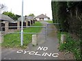
Wyatts Close alley
There are quite a few of these 'no cars, no cycles, pedestrians only' alleys in Corfe Mullen, really brings the place to a human scale. But I bet there isn't a kid in Corfe Mullen who hasn't cycled through here!
Image: © John Palmer
Taken: 1 Apr 2009
0.03 miles
2
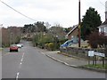
Wyatts Lane, Corfe Mullen
In the distance, our walk turned right into Wyatts Close, which connected via a 'no cycling' alley to Moorside Road and the main Wareham Road.
Image: © John Palmer
Taken: 1 Apr 2009
0.03 miles
3
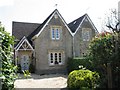
Lady Wimborne Cottages, Wareham Road
Also called 'Canford Estate Cottages', about 108 model cottages were built in Victorian times in the area by the Guest family of Canford. These are numbered 90 & 91 (not street numbers) and were built in 1888.
Image: © John Palmer
Taken: 1 Apr 2009
0.10 miles
4
Corfe Mullen, Lady Wimborne Cottages
On Wareham Road, next to Image A pair from about 110 estate cottages built by Lady Wimborne and her daughter between 1867 and 1904. Cottages have relief brick numbers above the front door; confusingly, these are not street numbers, but serial numbers. This pair is numbered 90 & 91, and dated 1888. http://archive.dorsetecho.co.uk/2000/11/6/109091.html
Image: © Mike Faherty
Taken: 28 Feb 2010
0.10 miles
5
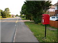
Corfe Mullen: postbox № BH21 152, Wareham Road
A small postbox diagonally opposite the Queen's Road turning, emptied finally at 4:30pm on weekdays and at 9:15am on Saturdays.
Image: © Chris Downer
Taken: 12 Jul 2009
0.11 miles
6
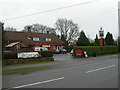
Corfe Mullen, The Dorset Soldier
Hall & Woodhouse pub on Wareham Road. Internally, central bar, lounge to left, public bar to right, dining room at back. Cask ales on offer at my visit: Badger, Hopping Hare, Tanglefoot. For some customer comments, see http://www.beerintheevening.com/pubs/s/27/2786/Dorset_Soldier/Corfe_Mullen
Image: © Mike Faherty
Taken: 28 Feb 2010
0.11 miles
7
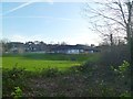
Corfe Mullen, Henbury View First School
First school on Hillside Road. http://www.henburyview.dorset.sch.uk/our-school/
Image: © Mike Faherty
Taken: 7 Jan 2012
0.13 miles
8
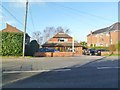
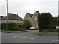
Corfe Mullen, veterinary practice
Hillside Veterinary Centre, on Wareham Road. http://www.hillsidevets.com/
Image: © Mike Faherty
Taken: 7 Jan 2012
0.13 miles
9
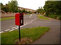
Corfe Mullen: postbox № BH21 217, Henbury View Road
This postbox serves a small estate that is even more modern than the rest of the Corfe Mullen sprawl; it is emptied finally at 4pm on weekdays and at 9am on Saturdays.
Image: © Chris Downer
Taken: 12 Jul 2009
0.13 miles
10
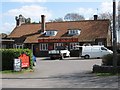
The Dorset Soldier, Wareham Road, Corfe Mullen
Almost in the centre of Corfe Mullen, on the main through road, the pub is named after the 39th Regiment of Foot, who fought over the 'Black Hole of Calcutta' in 1757
Image: © John Palmer
Taken: 1 Apr 2009
0.14 miles