IMAGES TAKEN NEAR TO
Vince Close, BOURNEMOUTH, BH11 9DJ
Introduction
This page details the photographs taken nearby to Vince Close, BH11 9DJ by members of the Geograph project.
The Geograph project started in 2005 with the aim of publishing, organising and preserving representative images for every square kilometre of Great Britain, Ireland and the Isle of Man.

There are currently over 7.5m images from over14,400 individuals and you can help contribute to the project by visiting https://www.geograph.org.uk
Image Map (Loading...)


Getting Data...Please wait
Leaflet Map data © OpenStreetMap
Images are licensed for reuse under creativecommons.org/licenses/by-sa/2.0
Notes
- Clicking on the map will re-center to the selected point.
- The higher the marker number, the further away the image location is from the centre of the postcode.
Image Listing (79 Images Found)
Images are licensed for reuse under creativecommons.org/licenses/by-sa/2.0
Image
Details
Distance
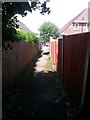
1
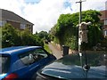
Kinson: footpath E12 from Vince Close
The dead end of Vince Close is busy with parked cars as we look across the roof of one of them, along this public footpath which leads onto public open space and continues to Summers Avenue.
The car here has a soft toy affixed to the aerial, which must help to locate the car in busy car parks.
See Image for the next view along the path, and links to further photos all along the route.
Image: © Chris Downer
Taken: 10 Jul 2016
0.01 miles
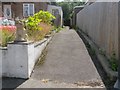
2
Kinson: footpath E12 reaches Vince Close
This public footpath, ultimately from Summers Avenue, arrives at its destination, the dead end of Vince Close. The house on the right has a high back-garden fence, but no fence to the front garden.
See Image for the view up the path from ahead, and Image] for the next view on the path from the open space behind us.
Image: © Chris Downer
Taken: 10 Jul 2016
0.01 miles
3
Kinson: footpath E12 heads for Vince Close
This public footpath has arrived on open space from Summers Avenue, and now heads back into suburbia by way of the little path ahead of us. It comes out at the dead end of Vince Close.
See Image for the next view along the path ahead, and Image for the view across the open space behind us.
Image: © Chris Downer
Taken: 10 Jul 2016
0.01 miles
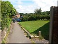
4
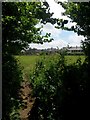
Kinson: the edge of open space behind Summers Avenue
Looking towards the rooftops of Vince Close at the northern edge of a sizable public open space.
Public footpath E12 comes out of the trees from Summers Avenue, just to our left, and proceeds in an undefined manner ahead, finding a paved path to Vince Close.
See Image for the next view along the footpath ahead, and Image] for the next view towards Summers Avenue.
Image: © Chris Downer
Taken: 10 Jul 2016
0.03 miles
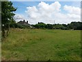
5
Kinson: footpath E12 enters open space
The public footpath from Summers Avenue emerges into public open space. Once out into the open, the path takes an undefined course to the left, heading for Vince Close.
See Image for the view along the path behind us, and Image for the northern edge of the open space, across which the path ahead goes.
Image: © Chris Downer
Taken: 10 Jul 2016
0.04 miles
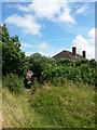
6
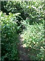
Kinson: brambly, nettly undergrowth on footpath E12
Looking along this public footpath as it leaves the open space and heads into an alleyway to Summers Avenue.
See Image for the next, more suburban view along the path ahead, and Image for the emergence behind us into open space.
Image: © Chris Downer
Taken: 10 Jul 2016
0.04 miles
7
Kinson: footpath E12 approaches Summers Avenue
Looking along this public footpath towards its northern end - the opposite view to Image
Behind us, the path heads into open space before leading to Vince Close - see Image for a view behind us and further links to photos along the route.
Image: © Chris Downer
Taken: 10 Jul 2016
0.05 miles
8
Kinson: a gargoyle guards footpath E12
Looking along this public footpath from Summers Avenue - the stone figure (is it actually a dog?) of course belongs to the house next door. The path leads into open space and then to the dead end of Vince Close.
See Image for the view towards us from ahead, and further links to photos all along the route.
Image: © Chris Downer
Taken: 10 Jul 2016
0.06 miles
9
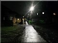
West Howe: lights on footpath E13 are brightly reflected
The nighttime view similar to Image shows the excellent lighting on this short public footpath reflecting strongly off the damp tarmac after rain all day. The path leads from Poole Lane, just behind us, to Wakely Road, ahead.
The grass patches either side are currently providing storage space for some roadworks on Poole Lane, hence the tyre marks churning up the grass during the recent wet weather.
See Image for towards us from midway along the path ahead, and Image for a view to our left, which is another public footpath.
Image: © Chris Downer
Taken: 1 Feb 2017
0.06 miles
10

Kinson: footpath E13 to Wakely Road
Alongside two houses that are set back from the road runs this useful cut-through - see Image] for a nighttime view and links to further photos through to the other end.
In front of the houses runs another footpath - see Image
Image: © Chris Downer
Taken: 29 Jun 2016
0.06 miles