IMAGES TAKEN NEAR TO
Nab End, BRADFORD, BD12 9BD
Introduction
This page details the photographs taken nearby to Nab End, BD12 9BD by members of the Geograph project.
The Geograph project started in 2005 with the aim of publishing, organising and preserving representative images for every square kilometre of Great Britain, Ireland and the Isle of Man.

There are currently over 7.5m images from over14,400 individuals and you can help contribute to the project by visiting https://www.geograph.org.uk
Image Map (Loading...)


Getting Data...Please wait
Leaflet Map data © OpenStreetMap
Images are licensed for reuse under creativecommons.org/licenses/by-sa/2.0
Notes
- Clicking on the map will re-center to the selected point.
- The higher the marker number, the further away the image location is from the centre of the postcode.
Image Listing (115 Images Found)
Images are licensed for reuse under creativecommons.org/licenses/by-sa/2.0
Image
Details
Distance
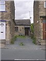
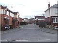
1
Houses of Nab End, Wyke Lane
There is an OS benchmark Image left of the black downpipe on the front of the house near the middle of the image
Image: © Luke Shaw
Taken: 23 Aug 2018
0.00 miles
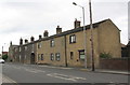
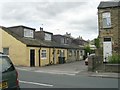
3
Former Co-op - Wyke Lane
Note the beehive high above the door.
Image: © Betty Longbottom
Taken: 8 Jul 2009
0.03 miles
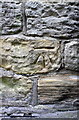
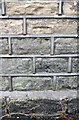
9
Nos. 21a and 21 Knowle Lane
There is an OS benchmark Image on the corner of the near house just inside the wooden gate
Image: © Luke Shaw
Taken: 23 Aug 2018
0.06 miles