IMAGES TAKEN NEAR TO
Tyseley Grove, BARNOLDSWICK, BB18 6NB
Introduction
This page details the photographs taken nearby to Tyseley Grove, BB18 6NB by members of the Geograph project.
The Geograph project started in 2005 with the aim of publishing, organising and preserving representative images for every square kilometre of Great Britain, Ireland and the Isle of Man.

There are currently over 7.5m images from over14,400 individuals and you can help contribute to the project by visiting https://www.geograph.org.uk
Image Map (Loading...)


Getting Data...Please wait
Leaflet Map data © OpenStreetMap
Images are licensed for reuse under creativecommons.org/licenses/by-sa/2.0
Notes
- Clicking on the map will re-center to the selected point.
- The higher the marker number, the further away the image location is from the centre of the postcode.
Image Listing (24 Images Found)
Images are licensed for reuse under creativecommons.org/licenses/by-sa/2.0
Image
Details
Distance
1
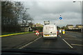
Stopped at roadworks near Earby
This is the gap along the A56 between Sough and Earby, though the speed limit stays at 30 mph on this stretch. Presumably the yellow pipes on the left are to be laid under the road ahead.
Image: © Bill Boaden
Taken: 12 Jan 2013
0.12 miles
2
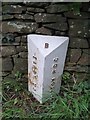
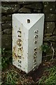
Old Boundary Marker
Parish Boundary Marker on the south side of Earby Road, just west of North Holme. On the boundary of Salterforth and Earby parishes, both formerly in the West Riding, but now both in Lancashire. In raised lettering EARBY UDC and SKIPTON RDC both vertically on adjacent faces with B on the top face. See also https://www.geograph.org.uk/photo/6206256.
Milestone Society National ID: YW_SALEAR01pb
Image: © D Phillips
Taken: 18 Sep 2019
0.13 miles
3
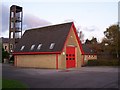
Earby Fire Station
Station P95 of Lancashire Fire and Rescue Service.
Image: © Aaron Collis
Taken: 27 Oct 2008
0.14 miles
6
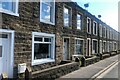
Terraced housing, Earby
A row of two-up two-downs on Colne Road
Image: © Eirian Evans
Taken: 16 Sep 2021
0.16 miles
7
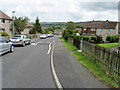
Warwick Drive, North Holme
A housing estate that has been attached onto the south western side of Earby, just off the road to Salterforth
Image: © Chris Heaton
Taken: 22 Jun 2011
0.16 miles
8
Boundary Marker.
Boundary between Earby RDC & Skipton UDC.
Image: © Andrew Riley
Taken: 9 Jul 2019
0.17 miles
9
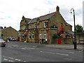
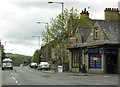
Station Hotel, Earby
There is a Station Hotel, but sadly no station or even railway now. The hotel stands opposite where the station used to be, on the main A56 road. Whether accommodation is still on offer, I do not know.
Image: © Dr Neil Clifton
Taken: 26 May 2008
0.17 miles