IMAGES TAKEN NEAR TO
Nelson Way, YEOVIL, BA21 5DT
Introduction
This page details the photographs taken nearby to Nelson Way, BA21 5DT by members of the Geograph project.
The Geograph project started in 2005 with the aim of publishing, organising and preserving representative images for every square kilometre of Great Britain, Ireland and the Isle of Man.

There are currently over 7.5m images from over14,400 individuals and you can help contribute to the project by visiting https://www.geograph.org.uk
Image Map (Loading...)


Getting Data...Please wait
Leaflet Map data © OpenStreetMap
Images are licensed for reuse under creativecommons.org/licenses/by-sa/2.0
Notes
- Clicking on the map will re-center to the selected point.
- The higher the marker number, the further away the image location is from the centre of the postcode.
Image Listing (5 Images Found)
Images are licensed for reuse under creativecommons.org/licenses/by-sa/2.0
Image
Details
Distance
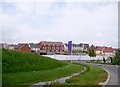
1
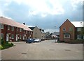
Wyndham Park new housing development
This large housing development lies to the north-east of Yeovil.
Image: © Sarah Smith
Taken: 17 May 2013
0.06 miles
2
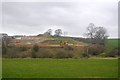
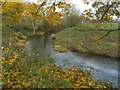
The edge of Yeovil
A small area of waste land beside Ashwood Drive on the north-east fringe of the town's suburbs. The trees on the right follow the line of a small stream descending to meet the River Yeo in the valley. The river, marked by the intermittent bushes, is a few metres into SX5817.
Image: © Derek Harper
Taken: 30 Aug 2007
0.15 miles
3
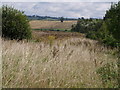
Wyndham Park - Yeovil
New housing development to the north-east of Yeovil, stretching towards Trent.
Image: © Sarah Smith
Taken: 17 May 2013
0.17 miles